Pozo de Almoguera geodata
Pozo de Almoguera (Castille-La Mancha) is a seat of a third-order administrative division; located in Spain in Europe/Madrid (GMT+2) time zone. With population of 152 people, there are 5413 cities with bigger population in this country. Compared to other cities in Spain, 65% of cities are located further ↑North; 54% of cities are located further ←West and 67.3% of cities have lower elevation than Pozo de Almoguera. Note1
Administrative division(s):
- Level 1: Castille-La Mancha
- Level 2: Provincia de Guadalajara
- Level 3: Pozo de Almoguera


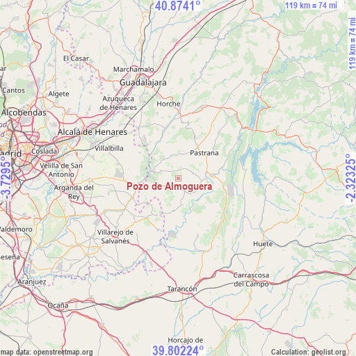
Pozo de Almoguera GPS coordinates[2]
40° 20' 25.08" North, 3° 1' 34.968" West
| Map corner | latitude | longitude |
|---|---|---|
| Upper-left | 40.8741°, | -3.7295° |
| Center: | 40.3403°, | -3.02638° |
| Lower-right: | 39.80224°, | -2.32325° |
| Map W x H: | 119.2×119.2 km | = 74.1×74.1mi |
| max Lat: | 43.74134° ⇑65% North |
| Pozo de Almoguera: | 40.3403° |
| min Lat: | ⇓35% South 27.64134° |
| min Long | Pozo de Almogue | max Long |
| -18.00367° | -3.02638° | 4.2899° |
| W 54%⇐ | ⇒46% E |
Elevation
Elevation of Pozo de Almoguera is 794 m = 2605 ft, and this is 196 m = 643 ft above average elevation for this country.
| Max E: |
1682 m = 5518 ft | 32.7% |
| Pozo de Almoguera | 794 m 2605 ft | |
| Avg. | 598 m = 1962 ft | |
Min E: |
0 m = 0 ft | 67.3% |
See also: Spain elevation on elevation.city.
Geographical zone
Pozo de Almoguera is located in North temperate zone (between Tropic of Cancer and the Arctic Circle). Distance of this Northern Tropic circle is 1879.5 km =1167.9 mi to South.| Distance of | km | miles | from Pozo de Almoguera |
|---|---|---|---|
| North Pole | 5521.6 | 3431 | to North |
| Arctic Circle | 2915.8 | 1811.8 | to North |
| Tropic Cancer | 1879.5 | 1167.9 | to South |
| Equator | 4485.4 | 2787.1 | to South |


Nearby cities:
15 places around Pozo de Almoguera: (largest is in red/bold)
• Albares
4 km =2.5 mi,  158°
158°
• Almoguera
6.1 km =3.8 mi,  142°
142°
• Ambite
13.1 km =8.1 mi,  265°
265°
• Brea de Tajo
13.4 km =8.3 mi,  207°
207°
• Driebes
10.7 km =6.6 mi,  186°
186°
• Escariche
7.6 km =4.7 mi,  342°
342°
• Escopete
8.3 km =5.2 mi,  12°
12°
• Fuentenovilla
6 km =3.7 mi,  294°
294°
• Hontoba
12.7 km =7.9 mi,  355°
355°
• Loranca de Tajuña
13.5 km =8.4 mi,  328°
328°
• Mazuecos
9 km =5.6 mi,  169°
169°
• Mondéjar
7.2 km =4.5 mi,  252°
252°
• Pastrana
12.4 km =7.7 mi,  45°
45°
• Yebra
5.4 km =3.4 mi,  69°
69°
• Zorita de los Canes
11.8 km =7.3 mi,  95°
95°
Sources, notices
• [Note1] Compared only with cities in Spain existing in our database
• [Src1] Map data: © OpenStreetMap contributors (CC-BY-SA)
• [Src2] Other city data from geonames.org with taken over terms of usage.
• [Src3] Geographical zone / Annual Mean Temperature by Robert A. Rohde @ Wikipedia
