Fuentenovilla geodata
Fuentenovilla (Castille-La Mancha) is a seat of a third-order administrative division; located in Spain in Europe/Madrid (GMT+2) time zone. With population of 378 people, there are 4215 cities with bigger population in this country. Compared to other cities in Spain, 64.7% of cities are located further ↑North; 52.9% of cities are located further ←West and 67.9% of cities have lower elevation than Fuentenovilla. Note1
Administrative division(s):
- Level 1: Castille-La Mancha
- Level 2: Provincia de Guadalajara
- Level 3: Fuentenovilla


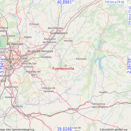
Fuentenovilla GPS coordinates[2]
40° 21' 44.928" North, 3° 5' 27.672" West
| Map corner | latitude | longitude |
|---|---|---|
| Upper-left | 40.8961°, | -3.79414° |
| Center: | 40.36248°, | -3.09102° |
| Lower-right: | 39.8246°, | -2.38789° |
| Map W x H: | 119.1×119.1 km | = 74×74mi |
| max Lat: | 43.74134° ⇑64.7% North |
| Fuentenovilla: | 40.36248° |
| min Lat: | ⇓35.3% South 27.64134° |
| min Long | Fuentenovilla | max Long |
| -18.00367° | -3.09102° | 4.2899° |
| W 52.9%⇐ | ⇒47.1% E |
Elevation
Elevation of Fuentenovilla is 798 m = 2618 ft, and this is 200 m = 656 ft above average elevation for this country.
| Max E: |
1682 m = 5518 ft | 32.1% |
| Fuentenovilla | 798 m 2618 ft | |
| Avg. | 598 m = 1962 ft | |
Min E: |
0 m = 0 ft | 67.9% |
See also: Spain elevation on elevation.city.
Geographical zone
Fuentenovilla is located in North temperate zone (between Tropic of Cancer and the Arctic Circle). Distance of this Northern Tropic circle is 1882 km =1169.4 mi to South.| Distance of | km | miles | from Fuentenovilla |
|---|---|---|---|
| North Pole | 5519.2 | 3429.5 | to North |
| Arctic Circle | 2913.3 | 1810.2 | to North |
| Tropic Cancer | 1882 | 1169.4 | to South |
| Equator | 4487.9 | 2788.7 | to South |


Nearby cities:
15 places around Fuentenovilla: (largest is in red/bold)
• Albares
9.3 km =5.8 mi,  131°
131°
• Almoguera
11.7 km =7.3 mi, 128°
• Ambite
8.3 km =5.2 mi,  245°
245°
• Escariche
5.8 km =3.6 mi,  33°
33°
• Escopete
9.2 km =5.7 mi,  52°
52°
• Hontoba
11.1 km =6.9 mi,  23°
23°
• Loranca de Tajuña
9.2 km =5.7 mi,  349°
349°
• Mondéjar
4.8 km =3 mi,  196°
196°
• Nuevo Baztán
12.7 km =7.9 mi,  272°
272°
• Orusco
13.1 km =8.1 mi,  227°
227°
• Pezuela de las Torres
9.2 km =5.7 mi,  310°
310°
• Pioz
13 km =8.1 mi,  327°
327°
• Pozo de Almoguera
6 km =3.7 mi,  114°
114°
• Villar del Olmo
12.5 km =7.8 mi,  255°
255°
• Yebra
10.6 km =6.6 mi,  93°
93°
Sources, notices
• [Note1] Compared only with cities in Spain existing in our database
• [Src1] Map data: © OpenStreetMap contributors (CC-BY-SA)
• [Src2] Other city data from geonames.org with taken over terms of usage.
• [Src3] Geographical zone / Annual Mean Temperature by Robert A. Rohde @ Wikipedia
