Portas geodata
Portas (Galicia) is a seat of a third-order administrative division; located in Spain in Europe/Madrid (GMT+2) time zone. With population of 3,177 people, there are 1670 cities with bigger population in this country. Compared to other cities in Spain, 89.1% of cities are located further ↓South; 97.5% of cities are located further →East and 95.4% of cities have higher elevation than Portas. Note1


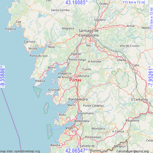
Portas GPS coordinates[2]
42° 35' 7.116" North, 8° 39' 20.628" West
| Map corner | latitude | longitude |
|---|---|---|
| Upper-left | 43.10085°, | -9.35886° |
| Center: | 42.58531°, | -8.65573° |
| Lower-right: | 42.06547°, | -7.95261° |
| Map W x H: | 115.1×115.1 km | = 71.5×71.5mi |
| max Lat: | 43.74134° ⇑10.9% North |
| Portas: | 42.58531° |
| min Lat: | ⇓89.1% South 27.64134° |
| min Long | Portas | max Long |
| -18.00367° | -8.65573° | 4.2899° |
| W 2.5%⇐ | ⇒97.5% E |
Elevation
Elevation of Portas is 23 m = 75 ft, and this is 575 m = 1886 ft below average elevation for this country.
| Max E: |
1682 m = 5518 ft | 95.4% |
| Avg. | 598 m = 1962 ft | |
| Portas | 23 m = 75 ft | |
Min E: |
0 m = 0 ft | 4.6% |
See also: Spain elevation on elevation.city.
Geographical zone
Portas is located in North temperate zone (between Tropic of Cancer and the Arctic Circle). Distance of this Northern Tropic circle is 2129.1 km =1323 mi to South.| Distance of | km | miles | from Portas |
|---|---|---|---|
| North Pole | 5272 | 3275.9 | to North |
| Arctic Circle | 2666.1 | 1656.6 | to North |
| Tropic Cancer | 2129.1 | 1323 | to South |
| Equator | 4735 | 2942.2 | to South |


Nearby cities:
15 places around Portas: (largest is in red/bold)
• Barro
4.3 km =2.7 mi,  140°
140°
• Caldas de Reis
2.4 km =1.5 mi,  26°
26°
• Cambados
15.2 km =9.4 mi,  237°
237°
• Catoira
10.7 km =6.6 mi,  328°
328°
• Cuntis
9.3 km =5.8 mi,  54°
54°
• Meis
12.2 km =7.6 mi,  219°
219°
• Moraña
7.1 km =4.4 mi,  123°
123°
• Poio
15.5 km =9.6 mi,  189°
189°
• Rianxo
15.1 km =9.4 mi,  298°
298°
• Ribadumia
10.9 km =6.8 mi,  225°
225°
• Sobradelo
10.4 km =6.5 mi,  268°
268°
• Valga
12.6 km =7.8 mi,  6°
6°
• Vilagarcía de Arousa
9 km =5.6 mi,  277°
277°
• Vilanova de Arousa
14.3 km =8.9 mi,  260°
260°
• Vilaxoán
11.3 km =7 mi, 268°
Sources, notices
• [Note1] Compared only with cities in Spain existing in our database
• [Src1] Map data: © OpenStreetMap contributors (CC-BY-SA)
• [Src2] Other city data from geonames.org with taken over terms of usage.
• [Src3] Geographical zone / Annual Mean Temperature by Robert A. Rohde @ Wikipedia
