Catoira geodata
Catoira (Galicia) is a seat of a third-order administrative division; located in Spain in Europe/Madrid (GMT+2) time zone. With population of 3,519 people, there are 1583 cities with bigger population in this country. Compared to other cities in Spain, 91% of cities are located further ↓South; 97.7% of cities are located further →East and 96.8% of cities have higher elevation than Catoira. Note1


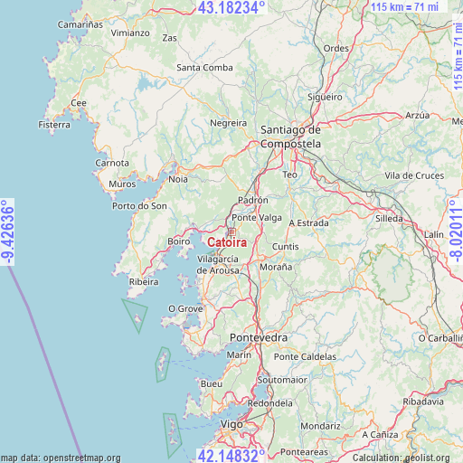
Catoira GPS coordinates[2]
42° 40' 2.928" North, 8° 43' 23.628" West
| Map corner | latitude | longitude |
|---|---|---|
| Upper-left | 43.18234°, | -9.42636° |
| Center: | 42.66748°, | -8.72323° |
| Lower-right: | 42.14832°, | -8.02011° |
| Map W x H: | 115×115 km | = 71.5×71.5mi |
| max Lat: | 43.74134° ⇑9% North |
| Catoira: | 42.66748° |
| min Lat: | ⇓91% South 27.64134° |
| min Long | Catoira | max Long |
| -18.00367° | -8.72323° | 4.2899° |
| W 2.3%⇐ | ⇒97.7% E |
Elevation
Elevation of Catoira is 16 m = 52 ft, and this is 582 m = 1909 ft below average elevation for this country.
| Max E: |
1682 m = 5518 ft | 96.8% |
| Avg. | 598 m = 1962 ft | |
| Catoira | 16 m = 52 ft | |
Min E: |
0 m = 0 ft | 3.2% |
See also: Spain elevation on elevation.city.
Geographical zone
Catoira is located in North temperate zone (between Tropic of Cancer and the Arctic Circle). Distance of this Northern Tropic circle is 2138.3 km =1328.7 mi to South.| Distance of | km | miles | from Catoira |
|---|---|---|---|
| North Pole | 5262.9 | 3270.2 | to North |
| Arctic Circle | 2657 | 1651 | to North |
| Tropic Cancer | 2138.3 | 1328.7 | to South |
| Equator | 4744.2 | 2947.9 | to South |


Nearby cities:
15 places around Catoira: (largest is in red/bold)
• Barro
15 km =9.3 mi,  146°
146°
• Boiro
13.4 km =8.3 mi,  260°
260°
• Caldas de Reis
9.6 km =6 mi,  136°
136°
• Cuntis
13.7 km =8.5 mi,  105°
105°
• Illa de Arousa
16.8 km =10.4 mi,  226°
226°
• Lousame
14.9 km =9.3 mi,  316°
316°
• Padrón
9.4 km =5.8 mi,  32°
32°
• Portas
10.7 km =6.6 mi, 148°
• Rianxo
8 km =5 mi, 255°
• Rois
10.7 km =6.6 mi,  7°
7°
• Sobradelo
10.6 km =6.6 mi,  207°
207°
• Valga
7.6 km =4.7 mi,  63°
63°
• Vilagarcía de Arousa
8.6 km =5.3 mi,  202°
202°
• Vilanova de Arousa
14.3 km =8.9 mi,  216°
216°
• Vilaxoán
11 km =6.8 mi, 211°
Sources, notices
• [Note1] Compared only with cities in Spain existing in our database
• [Src1] Map data: © OpenStreetMap contributors (CC-BY-SA)
• [Src2] Other city data from geonames.org with taken over terms of usage.
• [Src3] Geographical zone / Annual Mean Temperature by Robert A. Rohde @ Wikipedia
