Valga geodata
Valga (Galicia) is a seat of a third-order administrative division; located in Spain in Europe/Madrid (GMT+2) time zone. With population of 6,143 people, there are 1120 cities with bigger population in this country. Compared to other cities in Spain, 91.4% of cities are located further ↓South; 97.5% of cities are located further →East and 89.5% of cities have higher elevation than Valga. Note1


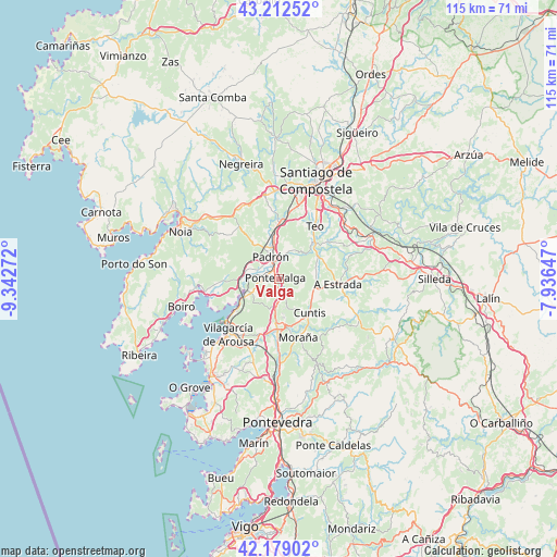
Valga GPS coordinates[2]
42° 41' 52.512" North, 8° 38' 22.524" West
| Map corner | latitude | longitude |
|---|---|---|
| Upper-left | 43.21252°, | -9.34272° |
| Center: | 42.69792°, | -8.63959° |
| Lower-right: | 42.17902°, | -7.93647° |
| Map W x H: | 114.9×114.9 km | = 71.4×71.4mi |
| max Lat: | 43.74134° ⇑8.6% North |
| Valga: | 42.69792° |
| min Lat: | ⇓91.4% South 27.64134° |
| min Long | Valga | max Long |
| -18.00367° | -8.63959° | 4.2899° |
| W 2.5%⇐ | ⇒97.5% E |
Elevation
Elevation of Valga is 75 m = 246 ft, and this is 523 m = 1716 ft below average elevation for this country.
| Max E: |
1682 m = 5518 ft | 89.5% |
| Avg. | 598 m = 1962 ft | |
| Valga | 75 m = 246 ft | |
Min E: |
0 m = 0 ft | 10.5% |
See also: Spain elevation on elevation.city.
Geographical zone
Valga is located in North temperate zone (between Tropic of Cancer and the Arctic Circle). Distance of this Northern Tropic circle is 2141.6 km =1330.7 mi to South.| Distance of | km | miles | from Valga |
|---|---|---|---|
| North Pole | 5259.5 | 3268.1 | to North |
| Arctic Circle | 2653.6 | 1648.9 | to North |
| Tropic Cancer | 2141.6 | 1330.7 | to South |
| Equator | 4747.6 | 2950 | to South |


Nearby cities:
15 places around Valga: (largest is in red/bold)
• A Estrada
12.4 km =7.7 mi,  94°
94°
• Barro
15.9 km =9.9 mi,  174°
174°
• Caldas de Reis
10.4 km =6.5 mi,  181°
181°
• Catoira
7.6 km =4.7 mi,  243°
243°
• Cuntis
9.5 km =5.9 mi,  138°
138°
• Moraña
17.1 km =10.6 mi,  164°
164°
• Padrón
4.9 km =3 mi,  339°
339°
• Portas
12.6 km =7.8 mi,  186°
186°
• Rianxo
15.5 km =9.6 mi,  249°
249°
• Ribeira
16.9 km =10.5 mi,  71°
71°
• Rois
9 km =5.6 mi,  323°
323°
• Sobradelo
17.3 km =10.7 mi,  222°
222°
• Teo
12.8 km =8 mi,  63°
63°
• Vedra
16 km =9.9 mi, 56°
• Vilagarcía de Arousa
15.2 km =9.4 mi, 222°
Sources, notices
• [Note1] Compared only with cities in Spain existing in our database
• [Src1] Map data: © OpenStreetMap contributors (CC-BY-SA)
• [Src2] Other city data from geonames.org with taken over terms of usage.
• [Src3] Geographical zone / Annual Mean Temperature by Robert A. Rohde @ Wikipedia
