Petín geodata
Petín (Galicia) is a seat of a third-order administrative division; located in Spain in Europe/Madrid (GMT+2) time zone. With population of 1,088 people, there are 2834 cities with bigger population in this country. Compared to other cities in Spain, 84.2% of cities are located further ↓South; 94.6% of cities are located further →East and 73.7% of cities have higher elevation than Petín. Note1


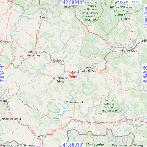
Petín GPS coordinates[2]
42° 22' 54.876" North, 7° 7' 44.364" West
| Map corner | latitude | longitude |
|---|---|---|
| Upper-left | 42.89914°, | -7.83211° |
| Center: | 42.38191°, | -7.12899° |
| Lower-right: | 41.86039°, | -6.42586° |
| Map W x H: | 115.5×115.5 km | = 71.8×71.8mi |
| max Lat: | 43.74134° ⇑15.8% North |
| Petín: | 42.38191° |
| min Lat: | ⇓84.2% South 27.64134° |
| min Long | Petín | max Long |
| -18.00367° | -7.12899° | 4.2899° |
| W 5.4%⇐ | ⇒94.6% E |
Elevation
Elevation of Petín is 319 m = 1047 ft, and this is 279 m = 915 ft below average elevation for this country.
| Max E: |
1682 m = 5518 ft | 73.7% |
| Avg. | 598 m = 1962 ft | |
| Petín | 319 m = 1047 ft | |
Min E: |
0 m = 0 ft | 26.3% |
See also: Spain elevation on elevation.city.
Geographical zone
Petín is located in North temperate zone (between Tropic of Cancer and the Arctic Circle). Distance of this Northern Tropic circle is 2106.5 km =1308.9 mi to South.| Distance of | km | miles | from Petín |
|---|---|---|---|
| North Pole | 5294.6 | 3289.9 | to North |
| Arctic Circle | 2688.7 | 1670.7 | to North |
| Tropic Cancer | 2106.5 | 1308.9 | to South |
| Equator | 4712.4 | 2928.1 | to South |


Nearby cities:
15 places around Petín: (largest is in red/bold)
• A Pobra do Brollon
29 km =18 mi,  311°
311°
• A Rúa
3 km =1.9 mi,  46°
46°
• Barjas
28.3 km =17.6 mi,  25°
25°
• Carucedo
32.2 km =20 mi,  67°
67°
• Castro Caldelas
24.4 km =15.2 mi,  267°
267°
• Manzaneda
11.7 km =7.3 mi,  226°
226°
• Montederramo
32.8 km =20.4 mi,  248°
248°
• O Barco de Valdeorras
12 km =7.5 mi, 71°
• Oencia
22.6 km =14 mi,  35°
35°
• Pobra de Trives
11.3 km =7 mi, 245°
• Porto
30.4 km =18.9 mi,  141°
141°
• Puente de Domingo Flórez
25.5 km =15.8 mi,  82°
82°
• Quiroga
15.9 km =9.9 mi, 311°
• Sobrado
27.4 km =17 mi,  56°
56°
• Vilariño de Conso
24.3 km =15.1 mi,  190°
190°
Sources, notices
• [Note1] Compared only with cities in Spain existing in our database
• [Src1] Map data: © OpenStreetMap contributors (CC-BY-SA)
• [Src2] Other city data from geonames.org with taken over terms of usage.
• [Src3] Geographical zone / Annual Mean Temperature by Robert A. Rohde @ Wikipedia
