Castro Caldelas geodata
Castro Caldelas (Galicia) is a seat of a third-order administrative division; located in Spain in Europe/Madrid (GMT+2) time zone. With population of 1,811 people, there are 2279 cities with bigger population in this country. Compared to other cities in Spain, 84% of cities are located further ↓South; 95.3% of cities are located further →East and 60.7% of cities have lower elevation than Castro Caldelas. Note1


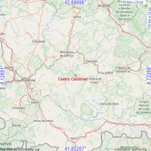
Castro Caldelas GPS coordinates[2]
42° 22' 25.176" North, 7° 25' 32.808" West
| Map corner | latitude | longitude |
|---|---|---|
| Upper-left | 42.89096°, | -8.12891° |
| Center: | 42.37366°, | -7.42578° |
| Lower-right: | 41.85207°, | -6.72266° |
| Map W x H: | 115.5×115.5 km | = 71.8×71.8mi |
| max Lat: | 43.74134° ⇑16% North |
| Castro Caldelas: | 42.37366° |
| min Lat: | ⇓84% South 27.64134° |
| min Long | Castro Caldelas | max Long |
| -18.00367° | -7.42578° | 4.2899° |
| W 4.7%⇐ | ⇒95.3% E |
Elevation
Elevation of Castro Caldelas is 749 m = 2457 ft, and this is 151 m = 495 ft above average elevation for this country.
| Max E: |
1682 m = 5518 ft | 39.3% |
| Castro Caldelas | 749 m 2457 ft | |
| Avg. | 598 m = 1962 ft | |
Min E: |
0 m = 0 ft | 60.7% |
See also: Spain elevation on elevation.city.
Geographical zone
Castro Caldelas is located in North temperate zone (between Tropic of Cancer and the Arctic Circle). Distance of this Northern Tropic circle is 2105.6 km =1308.4 mi to South.| Distance of | km | miles | from Castro Caldelas |
|---|---|---|---|
| North Pole | 5295.6 | 3290.5 | to North |
| Arctic Circle | 2689.7 | 1671.3 | to North |
| Tropic Cancer | 2105.6 | 1308.4 | to South |
| Equator | 4711.5 | 2927.6 | to South |


Nearby cities:
15 places around Castro Caldelas: (largest is in red/bold)
• A Pobra do Brollon
20.5 km =12.7 mi,  7°
7°
• A Rúa
26.7 km =16.6 mi,  83°
83°
• Baños de Molgas
25 km =15.5 mi,  234°
234°
• Esgos
22.9 km =14.2 mi,  256°
256°
• Lobios
9.5 km =5.9 mi,  293°
293°
• Luintra
25 km =15.5 mi,  279°
279°
• Maceda
21.8 km =13.5 mi,  237°
237°
• Manzaneda
17.4 km =10.8 mi,  114°
114°
• Monforte de Lemos
18 km =11.2 mi,  336°
336°
• Montederramo
12.6 km =7.8 mi,  209°
209°
• Pantón
21.4 km =13.3 mi,  318°
318°
• Petín
24.4 km =15.2 mi,  87°
87°
• Pobra de Trives
14.7 km =9.1 mi, 105°
• Quiroga
16.9 km =10.5 mi,  47°
47°
• Sober
16.4 km =10.2 mi,  306°
306°
Sources, notices
• [Note1] Compared only with cities in Spain existing in our database
• [Src1] Map data: © OpenStreetMap contributors (CC-BY-SA)
• [Src2] Other city data from geonames.org with taken over terms of usage.
• [Src3] Geographical zone / Annual Mean Temperature by Robert A. Rohde @ Wikipedia
