Manzanal de Arriba geodata
Manzanal de Arriba (Castille and León) is a seat of a third-order administrative division; located in Spain in Europe/Madrid (GMT+2) time zone. With population of 429 people, there are 4059 cities with bigger population in this country. Compared to other cities in Spain, 73.6% of cities are located further ↓South; 90.8% of cities are located further →East and 79.3% of cities have lower elevation than Manzanal de Arriba. Note1
Administrative division(s):
- Level 1: Castille and León
- Level 2: Provincia de Zamora
- Level 3: Manzanal de Arriba


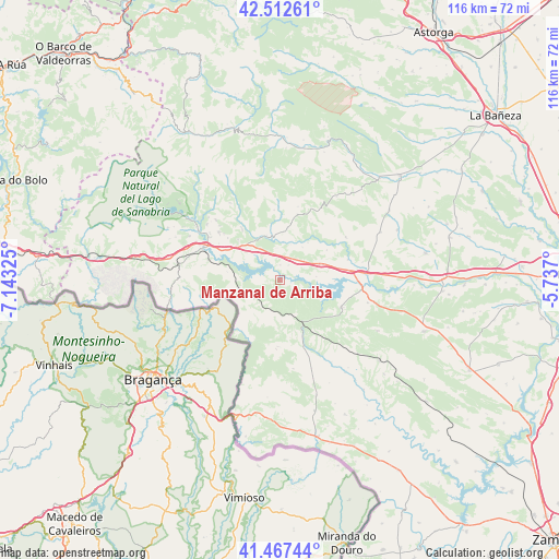
Manzanal de Arriba GPS coordinates[2]
41° 59' 31.812" North, 6° 26' 24.432" West
| Map corner | latitude | longitude |
|---|---|---|
| Upper-left | 42.51261°, | -7.14325° |
| Center: | 41.99217°, | -6.44012° |
| Lower-right: | 41.46744°, | -5.737° |
| Map W x H: | 116.2×116.2 km | = 72.2×72.2mi |
| max Lat: | 43.74134° ⇑26.4% North |
| Manzanal de Arriba: | 41.99217° |
| min Lat: | ⇓73.6% South 27.64134° |
| min Long | Manzanal de Arr | max Long |
| -18.00367° | -6.44012° | 4.2899° |
| W 9.2%⇐ | ⇒90.8% E |
Elevation
Elevation of Manzanal de Arriba is 891 m = 2923 ft, and this is 293 m = 961 ft above average elevation for this country.
| Max E: |
1682 m = 5518 ft | 20.7% |
| Manzanal de Arriba | 891 m 2923 ft | |
| Avg. | 598 m = 1962 ft | |
Min E: |
0 m = 0 ft | 79.3% |
See also: Spain elevation on elevation.city.
Geographical zone
Manzanal de Arriba is located in North temperate zone (between Tropic of Cancer and the Arctic Circle). Distance of this Northern Tropic circle is 2063.2 km =1282 mi to South.| Distance of | km | miles | from Manzanal de Arriba |
|---|---|---|---|
| North Pole | 5338 | 3316.9 | to North |
| Arctic Circle | 2732.1 | 1697.6 | to North |
| Tropic Cancer | 2063.2 | 1282 | to South |
| Equator | 4669.1 | 2901.2 | to South |


Nearby cities:
15 places around Manzanal de Arriba: (largest is in red/bold)
• Asturianos
7.8 km =4.8 mi,  328°
328°
• Cernadilla
3.7 km =2.3 mi,  30°
30°
• Espadañedo
14.3 km =8.9 mi,  15°
15°
• Figueruela de Arriba
13.7 km =8.5 mi,  181°
181°
• Justel
21.1 km =13.1 mi, 34°
• Mahide
14.6 km =9.1 mi,  159°
159°
• Manzanal de los Infantes
8.4 km =5.2 mi, 34°
• Mombuey
9.7 km =6 mi,  69°
69°
• Muelas de los Caballeros
17.4 km =10.8 mi, 29°
• Palacios de Sanabria
10.1 km =6.3 mi,  317°
317°
• Peque
16.3 km =10.1 mi,  56°
56°
• Puebla de Sanabria
17.4 km =10.8 mi,  293°
293°
• Robleda-Cervantes
16.2 km =10.1 mi,  308°
308°
• San Justo
21.8 km =13.5 mi, 315°
• Villardeciervos
13.9 km =8.6 mi,  113°
113°
Sources, notices
• [Note1] Compared only with cities in Spain existing in our database
• [Src1] Map data: © OpenStreetMap contributors (CC-BY-SA)
• [Src2] Other city data from geonames.org with taken over terms of usage.
• [Src3] Geographical zone / Annual Mean Temperature by Robert A. Rohde @ Wikipedia
