Penelles geodata
Penelles (Catalonia) is a seat of a third-order administrative division; located in Spain in Europe/Madrid (GMT+2) time zone. In our database, there are 6762 cities with bigger population. Compared to other cities in Spain, 67.3% of cities are located further ↓South; 90.3% of cities are located further ←West and 77.6% of cities have higher elevation than Penelles. Note1


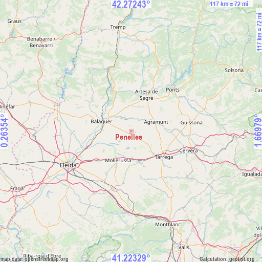
Penelles GPS coordinates[2]
41° 45' 0" North, 0° 58' 0.012" East
| Map corner | latitude | longitude |
|---|---|---|
| Upper-left | 42.27243°, | 0.26354° |
| Center: | 41.75°, | 0.96667° |
| Lower-right: | 41.22329°, | 1.66979° |
| Map W x H: | 116.7×116.7 km | = 72.5×72.5mi |
| max Lat: | 43.74134° ⇑32.7% North |
| Penelles: | 41.75° |
| min Lat: | ⇓67.3% South 27.64134° |
| min Long | Penelles | max Long |
| -18.00367° | 0.96667° | 4.2899° |
| W 90.3%⇐ | ⇒9.7% E |
Elevation
Elevation of Penelles is 262 m = 860 ft, and this is 336 m = 1102 ft below average elevation for this country.
| Max E: |
1682 m = 5518 ft | 77.6% |
| Avg. | 598 m = 1962 ft | |
| Penelles | 262 m = 860 ft | |
Min E: |
0 m = 0 ft | 22.4% |
See also: Spain elevation on elevation.city.
Geographical zone
Penelles is located in North temperate zone (between Tropic of Cancer and the Arctic Circle). Distance of this Northern Tropic circle is 2036.2 km =1265.2 mi to South.| Distance of | km | miles | from Penelles |
|---|---|---|---|
| North Pole | 5364.9 | 3333.6 | to North |
| Arctic Circle | 2759 | 1714.4 | to North |
| Tropic Cancer | 2036.2 | 1265.2 | to South |
| Equator | 4642.2 | 2884.5 | to South |


Nearby cities:
15 places around Penelles: (largest is in red/bold)
• Agramunt
11.5 km =7.1 mi,  69°
69°
• Barbens
9 km =5.6 mi,  152°
152°
• Bellcaire d'Urgell
4.1 km =2.5 mi,  270°
270°
• Castellnou de Seana
11.3 km =7 mi,  178°
178°
• Castellserà
2.8 km =1.7 mi,  90°
90°
• Cubells
11.2 km =7 mi,  356°
356°
• Golmés
13.3 km =8.3 mi,  192°
192°
• Ivars d'Urgell
7.9 km =4.9 mi,  167°
167°
• La Fuliola
5.8 km =3.6 mi,  133°
133°
• Linyola
6.9 km =4.3 mi,  216°
216°
• Montgai
5.6 km =3.5 mi,  0°
0°
• Preixens
8.7 km =5.4 mi,  53°
53°
• Tornabous
9 km =5.6 mi, 126°
• Vallfogona de Balaguer
12.7 km =7.9 mi, 271°
• el Poal
11.1 km =6.9 mi,  228°
228°
Sources, notices
• [Note1] Compared only with cities in Spain existing in our database
• [Src1] Map data: © OpenStreetMap contributors (CC-BY-SA)
• [Src2] Other city data from geonames.org with taken over terms of usage.
• [Src3] Geographical zone / Annual Mean Temperature by Robert A. Rohde @ Wikipedia
