Agramunt geodata
Agramunt (Catalonia) is a seat of a third-order administrative division; located in Spain in Europe/Madrid (GMT+2) time zone. With population of 5,351 people, there are 1241 cities with bigger population in this country. Compared to other cities in Spain, 68.2% of cities are located further ↓South; 90.8% of cities are located further ←West and 72.2% of cities have higher elevation than Agramunt. Note1


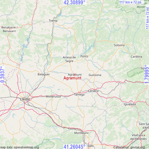
Agramunt GPS coordinates[2]
41° 47' 12.696" North, 1° 5' 48.588" East
| Map corner | latitude | longitude |
|---|---|---|
| Upper-left | 42.30899°, | 0.3937° |
| Center: | 41.78686°, | 1.09683° |
| Lower-right: | 41.26045°, | 1.79995° |
| Map W x H: | 116.6×116.6 km | = 72.5×72.5mi |
| max Lat: | 43.74134° ⇑31.8% North |
| Agramunt: | 41.78686° |
| min Lat: | ⇓68.2% South 27.64134° |
| min Long | Agramunt | max Long |
| -18.00367° | 1.09683° | 4.2899° |
| W 90.8%⇐ | ⇒9.2% E |
Elevation
Elevation of Agramunt is 342 m = 1122 ft, and this is 256 m = 840 ft below average elevation for this country.
| Max E: |
1682 m = 5518 ft | 72.2% |
| Avg. | 598 m = 1962 ft | |
| Agramunt | 342 m = 1122 ft | |
Min E: |
0 m = 0 ft | 27.8% |
See also: Spain elevation on elevation.city.
Geographical zone
Agramunt is located in North temperate zone (between Tropic of Cancer and the Arctic Circle). Distance of this Northern Tropic circle is 2040.3 km =1267.8 mi to South.| Distance of | km | miles | from Agramunt |
|---|---|---|---|
| North Pole | 5360.8 | 3331 | to North |
| Arctic Circle | 2754.9 | 1711.8 | to North |
| Tropic Cancer | 2040.3 | 1267.8 | to South |
| Equator | 4646.3 | 2887.1 | to South |


Nearby cities:
15 places around Agramunt: (largest is in red/bold)
• Anglesola
14.5 km =9 mi,  184°
184°
• Artesa de Segre
12.7 km =7.9 mi,  340°
340°
• Barbens
13.7 km =8.5 mi,  208°
208°
• Bellcaire d'Urgell
15.5 km =9.6 mi,  254°
254°
• Castellserà
9 km =5.6 mi,  242°
242°
• Cubells
13.4 km =8.3 mi,  301°
301°
• Ivars d'Urgell
15 km =9.3 mi,  217°
217°
• La Fuliola
10.5 km =6.5 mi, 218°
• Montgai
10.9 km =6.8 mi,  277°
277°
• Ossó de Sió
6.3 km =3.9 mi,  124°
124°
• Penelles
11.5 km =7.1 mi, 249°
• Ponts
16.1 km =10 mi,  26°
26°
• Preixens
4 km =2.5 mi,  285°
285°
• Tornabous
10.2 km =6.3 mi,  200°
200°
• Tàrrega
15.9 km =9.9 mi,  167°
167°
Sources, notices
• [Note1] Compared only with cities in Spain existing in our database
• [Src1] Map data: © OpenStreetMap contributors (CC-BY-SA)
• [Src2] Other city data from geonames.org with taken over terms of usage.
• [Src3] Geographical zone / Annual Mean Temperature by Robert A. Rohde @ Wikipedia
