Cubells geodata
Cubells (Catalonia) is a seat of a third-order administrative division; located in Spain in Europe/Madrid (GMT+2) time zone. With population of 389 people, there are 4168 cities with bigger population in this country. Compared to other cities in Spain, 69.8% of cities are located further ↓South; 90.3% of cities are located further ←West and 62.5% of cities have higher elevation than Cubells. Note1


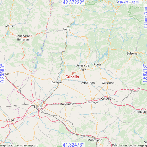
Cubells GPS coordinates[2]
41° 51' 2.232" North, 0° 57' 32.4" East
| Map corner | latitude | longitude |
|---|---|---|
| Upper-left | 42.37222°, | 0.25588° |
| Center: | 41.85062°, | 0.959° |
| Lower-right: | 41.32473°, | 1.66213° |
| Map W x H: | 116.5×116.5 km | = 72.4×72.4mi |
| max Lat: | 43.74134° ⇑30.2% North |
| Cubells: | 41.85062° |
| min Lat: | ⇓69.8% South 27.64134° |
| min Long | Cubells | max Long |
| -18.00367° | 0.959° | 4.2899° |
| W 90.3%⇐ | ⇒9.7% E |
Elevation
Elevation of Cubells is 493 m = 1617 ft, and this is 105 m = 344 ft below average elevation for this country.
| Max E: |
1682 m = 5518 ft | 62.5% |
| Avg. | 598 m = 1962 ft | |
| Cubells | 493 m = 1617 ft | |
Min E: |
0 m = 0 ft | 37.5% |
See also: Spain elevation on elevation.city.
Geographical zone
Cubells is located in North temperate zone (between Tropic of Cancer and the Arctic Circle). Distance of this Northern Tropic circle is 2047.4 km =1272.2 mi to South.| Distance of | km | miles | from Cubells |
|---|---|---|---|
| North Pole | 5353.7 | 3326.6 | to North |
| Arctic Circle | 2747.8 | 1707.4 | to North |
| Tropic Cancer | 2047.4 | 1272.2 | to South |
| Equator | 4653.4 | 2891.5 | to South |


Nearby cities:
15 places around Cubells: (largest is in red/bold)
• Agramunt
13.4 km =8.3 mi,  121°
121°
• Artesa de Segre
8.7 km =5.4 mi,  55°
55°
• Balaguer
13.9 km =8.6 mi,  241°
241°
• Bellcaire d'Urgell
11.7 km =7.3 mi,  197°
197°
• Camarasa
7.2 km =4.5 mi,  291°
291°
• Castellserà
11.7 km =7.3 mi,  163°
163°
• Castelló de Farfanya
19.1 km =11.9 mi,  258°
258°
• Ivars d'Urgell
19.1 km =11.9 mi,  173°
173°
• La Fuliola
16 km =9.9 mi, 162°
• Linyola
17.1 km =10.6 mi,  191°
191°
• Montgai
5.7 km =3.5 mi, 173°
• Penelles
11.2 km =7 mi,  176°
176°
• Preixens
9.7 km =6 mi,  128°
128°
• Tornabous
18.4 km =11.4 mi,  154°
154°
• Vallfogona de Balaguer
16.3 km =10.1 mi,  227°
227°
Sources, notices
• [Note1] Compared only with cities in Spain existing in our database
• [Src1] Map data: © OpenStreetMap contributors (CC-BY-SA)
• [Src2] Other city data from geonames.org with taken over terms of usage.
• [Src3] Geographical zone / Annual Mean Temperature by Robert A. Rohde @ Wikipedia
