Sacedón geodata
Sacedón (Castille-La Mancha) is a seat of a third-order administrative division; located in Spain in Europe/Madrid (GMT+2) time zone. With population of 1,674 people, there are 2356 cities with bigger population in this country. Compared to other cities in Spain, 62.3% of cities are located further ↑North; 58.2% of cities are located further ←West and 60.3% of cities have lower elevation than Sacedón. Note1
Administrative division(s):
- Level 1: Castille-La Mancha
- Level 2: Provincia de Guadalajara
- Level 3: Sacedón


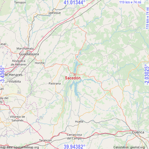
Sacedón GPS coordinates[2]
40° 28' 50.736" North, 2° 44' 0.132" West
| Map corner | latitude | longitude |
|---|---|---|
| Upper-left | 41.01344°, | -3.4365° |
| Center: | 40.48076°, | -2.73337° |
| Lower-right: | 39.94382°, | -2.03025° |
| Map W x H: | 118.9×118.9 km | = 73.9×73.9mi |
| max Lat: | 43.74134° ⇑62.3% North |
| Sacedón: | 40.48076° |
| min Lat: | ⇓37.7% South 27.64134° |
| min Long | Sacedón | max Long |
| -18.00367° | -2.73337° | 4.2899° |
| W 58.2%⇐ | ⇒41.8% E |
Elevation
Elevation of Sacedón is 747 m = 2451 ft, and this is 149 m = 489 ft above average elevation for this country.
| Max E: |
1682 m = 5518 ft | 39.7% |
| Sacedón | 747 m 2451 ft | |
| Avg. | 598 m = 1962 ft | |
Min E: |
0 m = 0 ft | 60.3% |
See also: Spain elevation on elevation.city.
Geographical zone
Sacedón is located in North temperate zone (between Tropic of Cancer and the Arctic Circle). Distance of this Northern Tropic circle is 1895.1 km =1177.6 mi to South.| Distance of | km | miles | from Sacedón |
|---|---|---|---|
| North Pole | 5506 | 3421.3 | to North |
| Arctic Circle | 2900.1 | 1802 | to North |
| Tropic Cancer | 1895.1 | 1177.6 | to South |
| Equator | 4501 | 2796.8 | to South |


Nearby cities:
15 places around Sacedón: (largest is in red/bold)
• Alcocer
10.6 km =6.6 mi,  96°
96°
• Alcohujate
12.2 km =7.6 mi,  125°
125°
• Alhóndiga
9.2 km =5.7 mi,  303°
303°
• Alique
14 km =8.7 mi,  32°
32°
• Alocén
10.5 km =6.5 mi,  352°
352°
• Auñón
6.5 km =4 mi,  309°
309°
• Berninches
11.6 km =7.2 mi,  330°
330°
• Buendía
12.9 km =8 mi,  188°
188°
• Cañaveruelas
12.1 km =7.5 mi,  137°
137°
• Chillarón del Rey
13.5 km =8.4 mi,  15°
15°
• Fuentelencina
13.2 km =8.2 mi,  288°
288°
• Millana
14 km =8.7 mi,  77°
77°
• Pareja
11 km =6.8 mi,  40°
40°
• Sayatón
15.4 km =9.6 mi,  220°
220°
• Valdeconcha
12.4 km =7.7 mi,  257°
257°
Sources, notices
• [Note1] Compared only with cities in Spain existing in our database
• [Src1] Map data: © OpenStreetMap contributors (CC-BY-SA)
• [Src2] Other city data from geonames.org with taken over terms of usage.
• [Src3] Geographical zone / Annual Mean Temperature by Robert A. Rohde @ Wikipedia
