Alocén geodata
Alocén (Castille-La Mancha) is a seat of a third-order administrative division; located in Spain in Europe/Madrid (GMT+2) time zone. With population of 181 people, there are 5181 cities with bigger population in this country. Compared to other cities in Spain, 60.4% of cities are located further ↑North; 58.1% of cities are located further ←West and 84.4% of cities have lower elevation than Alocén. Note1
Administrative division(s):
- Level 1: Castille-La Mancha
- Level 2: Provincia de Guadalajara
- Level 3: Alocén


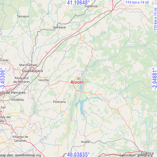
Alocén GPS coordinates[2]
40° 34' 28.38" North, 2° 44' 59.748" West
| Map corner | latitude | longitude |
|---|---|---|
| Upper-left | 41.10648°, | -3.45306° |
| Center: | 40.57455°, | -2.74993° |
| Lower-right: | 40.03835°, | -2.04681° |
| Map W x H: | 118.8×118.8 km | = 73.8×73.8mi |
| max Lat: | 43.74134° ⇑60.4% North |
| Alocén: | 40.57455° |
| min Lat: | ⇓39.6% South 27.64134° |
| min Long | Alocén | max Long |
| -18.00367° | -2.74993° | 4.2899° |
| W 58.1%⇐ | ⇒41.9% E |
Elevation
Elevation of Alocén is 944 m = 3097 ft, and this is 346 m = 1135 ft above average elevation for this country.
| Max E: |
1682 m = 5518 ft | 15.6% |
| Alocén | 944 m 3097 ft | |
| Avg. | 598 m = 1962 ft | |
Min E: |
0 m = 0 ft | 84.4% |
See also: Spain elevation on elevation.city.
Geographical zone
Alocén is located in North temperate zone (between Tropic of Cancer and the Arctic Circle). Distance of this Northern Tropic circle is 1905.5 km =1184 mi to South.| Distance of | km | miles | from Alocén |
|---|---|---|---|
| North Pole | 5495.6 | 3414.8 | to North |
| Arctic Circle | 2889.7 | 1795.6 | to North |
| Tropic Cancer | 1905.5 | 1184 | to South |
| Equator | 4511.5 | 2803.3 | to South |


Nearby cities:
15 places around Alocén: (largest is in red/bold)
• Alhóndiga
8.2 km =5.1 mi,  229°
229°
• Alique
9 km =5.6 mi,  81°
81°
• Auñón
7.3 km =4.5 mi,  209°
209°
• Berninches
4.3 km =2.7 mi,  264°
264°
• Budia
5.9 km =3.7 mi,  353°
353°
• Chillarón del Rey
5.6 km =3.5 mi,  62°
62°
• Durón
6 km =3.7 mi,  19°
19°
• Irueste
12.6 km =7.8 mi,  289°
289°
• Mantiel
8.8 km =5.5 mi, 56°
• Pareja
8.8 km =5.5 mi,  103°
103°
• Peñalver
11.8 km =7.3 mi,  273°
273°
• Sacedón
10.5 km =6.5 mi,  172°
172°
• San Andrés del Rey
9.2 km =5.7 mi,  320°
320°
• Yélamos de Abajo
11.1 km =6.9 mi,  304°
304°
• Yélamos de Arriba
10.7 km =6.6 mi,  312°
312°
Sources, notices
• [Note1] Compared only with cities in Spain existing in our database
• [Src1] Map data: © OpenStreetMap contributors (CC-BY-SA)
• [Src2] Other city data from geonames.org with taken over terms of usage.
• [Src3] Geographical zone / Annual Mean Temperature by Robert A. Rohde @ Wikipedia
