Calatayud geodata
Calatayud (Aragon) is a seat of a third-order administrative division; located in Spain in Europe/Madrid (GMT+2) time zone. With population of 21,933 people, there are 430 cities with bigger population in this country. Compared to other cities in Spain, 56.4% of cities are located further ↓South; 71.5% of cities are located further ←West and 58.9% of cities have higher elevation than Calatayud. Note1


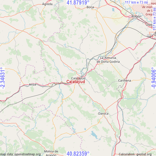
Calatayud GPS coordinates[2]
41° 21' 12.708" North, 1° 38' 35.448" West
| Map corner | latitude | longitude |
|---|---|---|
| Upper-left | 41.87919°, | -2.34631° |
| Center: | 41.35353°, | -1.64318° |
| Lower-right: | 40.82359°, | -0.94006° |
| Map W x H: | 117.4×117.4 km | = 72.9×72.9mi |
| max Lat: | 43.74134° ⇑43.6% North |
| Calatayud: | 41.35353° |
| min Lat: | ⇓56.4% South 27.64134° |
| min Long | Calatayud | max Long |
| -18.00367° | -1.64318° | 4.2899° |
| W 71.5%⇐ | ⇒28.5% E |
Elevation
Elevation of Calatayud is 542 m = 1778 ft, and this is 56 m = 184 ft below average elevation for this country.
| Max E: |
1682 m = 5518 ft | 58.9% |
| Avg. | 598 m = 1962 ft | |
| Calatayud | 542 m = 1778 ft | |
Min E: |
0 m = 0 ft | 41.1% |
See also: Spain elevation on elevation.city.
Geographical zone
Calatayud is located in North temperate zone (between Tropic of Cancer and the Arctic Circle). Distance of this Northern Tropic circle is 1992.2 km =1237.9 mi to South.| Distance of | km | miles | from Calatayud |
|---|---|---|---|
| North Pole | 5409 | 3361 | to North |
| Arctic Circle | 2803.1 | 1741.8 | to North |
| Tropic Cancer | 1992.2 | 1237.9 | to South |
| Equator | 4598.1 | 2857.1 | to South |


Nearby cities:
15 places around Calatayud: (largest is in red/bold)
• Aniñon
11.4 km =7.1 mi,  333°
333°
• Cervera de la Cañada
11.7 km =7.3 mi,  318°
318°
• Maluenda
7.7 km =4.8 mi,  162°
162°
• Mara
12.6 km =7.8 mi,  124°
124°
• Morata de Jiloca
12.7 km =7.9 mi, 158°
• Munébrega
12.4 km =7.7 mi,  204°
204°
• Olvés
12.7 km =7.9 mi,  181°
181°
• Paracuellos de Jiloca
4.4 km =2.7 mi, 176°
• Paracuellos de la Ribera
10.2 km =6.3 mi,  41°
41°
• Sediles
9.3 km =5.8 mi,  95°
95°
• Terrer
6.5 km =4 mi,  244°
244°
• Torralba de Ribota
7.9 km =4.9 mi, 334°
• Valtorres
10.2 km =6.3 mi,  233°
233°
• Velilla de Jiloca
9.3 km =5.8 mi, 159°
• Villalba de Perejil
8.4 km =5.2 mi,  110°
110°
Sources, notices
• [Note1] Compared only with cities in Spain existing in our database
• [Src1] Map data: © OpenStreetMap contributors (CC-BY-SA)
• [Src2] Other city data from geonames.org with taken over terms of usage.
• [Src3] Geographical zone / Annual Mean Temperature by Robert A. Rohde @ Wikipedia
