Magán geodata
Magán (Castille-La Mancha) is a seat of a third-order administrative division; located in Spain in Europe/Madrid (GMT+2) time zone. With population of 1,668 people, there are 2361 cities with bigger population in this country. Compared to other cities in Spain, 70.9% of cities are located further ↑North; 58.7% of cities are located further →East and 62.9% of cities have higher elevation than Magán. Note1


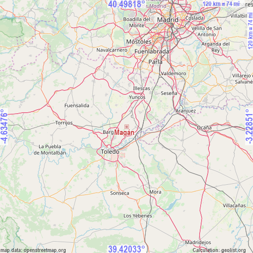
Magán GPS coordinates[2]
39° 57' 40.968" North, 3° 55' 53.904" West
| Map corner | latitude | longitude |
|---|---|---|
| Upper-left | 40.49818°, | -4.63476° |
| Center: | 39.96138°, | -3.93164° |
| Lower-right: | 39.42033°, | -3.22851° |
| Map W x H: | 119.8×119.8 km | = 74.4×74.4mi |
| max Lat: | 43.74134° ⇑70.9% North |
| Magán: | 39.96138° |
| min Lat: | ⇓29.1% South 27.64134° |
| min Long | Magán | max Long |
| -18.00367° | -3.93164° | 4.2899° |
| W 41.3%⇐ | ⇒58.7% E |
Elevation
Elevation of Magán is 488 m = 1601 ft, and this is 110 m = 361 ft below average elevation for this country.
| Max E: |
1682 m = 5518 ft | 62.9% |
| Avg. | 598 m = 1962 ft | |
| Magán | 488 m = 1601 ft | |
Min E: |
0 m = 0 ft | 37.1% |
See also: Spain elevation on elevation.city.
Geographical zone
Magán is located in North temperate zone (between Tropic of Cancer and the Arctic Circle). Distance of this Northern Tropic circle is 1837.4 km =1141.7 mi to South.| Distance of | km | miles | from Magán |
|---|---|---|---|
| North Pole | 5563.8 | 3457.2 | to North |
| Arctic Circle | 2957.9 | 1838 | to North |
| Tropic Cancer | 1837.4 | 1141.7 | to South |
| Equator | 4443.3 | 2760.9 | to South |


Nearby cities:
15 places around Magán: (largest is in red/bold)
• Añover de Tajo
14.5 km =9 mi,  77°
77°
• Bargas
7.8 km =4.8 mi,  253°
253°
• Cabañas de la Sagra
5.1 km =3.2 mi,  346°
346°
• Camarenilla
13.8 km =8.6 mi,  296°
296°
• Cobeja
9.2 km =5.7 mi,  44°
44°
• La Alameda de la Sagra
13.1 km =8.1 mi,  64°
64°
• Lominchar
14.7 km =9.1 mi, 348°
• Mocejón
2.7 km =1.7 mi,  153°
153°
• Numancia de la Sagra
14.3 km =8.9 mi,  28°
28°
• Olías del Rey
5.1 km =3.2 mi, 248°
• Pantoja
12.4 km =7.7 mi, 42°
• Recas
11.4 km =7.1 mi,  333°
333°
• Toledo
13.9 km =8.6 mi,  214°
214°
• Villaseca de la Sagra
4.2 km =2.6 mi,  89°
89°
• Yuncler
9.2 km =5.7 mi,  17°
17°
Sources, notices
• [Note1] Compared only with cities in Spain existing in our database
• [Src1] Map data: © OpenStreetMap contributors (CC-BY-SA)
• [Src2] Other city data from geonames.org with taken over terms of usage.
• [Src3] Geographical zone / Annual Mean Temperature by Robert A. Rohde @ Wikipedia
