Lominchar geodata
Lominchar (Castille-La Mancha) is a seat of a third-order administrative division; located in Spain in Europe/Madrid (GMT+2) time zone. With population of 1,453 people, there are 2507 cities with bigger population in this country. Compared to other cities in Spain, 68.9% of cities are located further ↑North; 59.2% of cities are located further →East and 50.9% of cities have higher elevation than Lominchar. Note1
Administrative division(s):
- Level 1: Castille-La Mancha
- Level 2: Province of Toledo
- Level 3: Lominchar


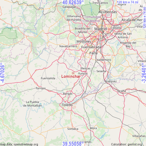
Lominchar GPS coordinates[2]
40° 5' 26.196" North, 3° 58' 1.668" West
| Map corner | latitude | longitude |
|---|---|---|
| Upper-left | 40.62639°, | -4.67026° |
| Center: | 40.09061°, | -3.96713° |
| Lower-right: | 39.55058°, | -3.26401° |
| Map W x H: | 119.6×119.6 km | = 74.3×74.3mi |
| max Lat: | 43.74134° ⇑68.9% North |
| Lominchar: | 40.09061° |
| min Lat: | ⇓31.1% South 27.64134° |
| min Long | Lominchar | max Long |
| -18.00367° | -3.96713° | 4.2899° |
| W 40.8%⇐ | ⇒59.2% E |
Elevation
Elevation of Lominchar is 649 m = 2129 ft, and this is 51 m = 167 ft above average elevation for this country.
| Max E: |
1682 m = 5518 ft | 50.9% |
| Lominchar | 649 m 2129 ft | |
| Avg. | 598 m = 1962 ft | |
Min E: |
0 m = 0 ft | 49.1% |
See also: Spain elevation on elevation.city.
Geographical zone
Lominchar is located in North temperate zone (between Tropic of Cancer and the Arctic Circle). Distance of this Northern Tropic circle is 1851.7 km =1150.6 mi to South.| Distance of | km | miles | from Lominchar |
|---|---|---|---|
| North Pole | 5549.4 | 3448.2 | to North |
| Arctic Circle | 2943.5 | 1829 | to North |
| Tropic Cancer | 1851.7 | 1150.6 | to South |
| Equator | 4457.7 | 2769.9 | to South |


Nearby cities:
15 places around Lominchar: (largest is in red/bold)
• Cabañas de la Sagra
9.6 km =6 mi,  168°
168°
• Camarenilla
12.4 km =7.7 mi,  228°
228°
• Carranque
10.4 km =6.5 mi,  32°
32°
• Casarrubios del Monte
12.2 km =7.6 mi,  331°
331°
• Cedillo del Condado
4.6 km =2.9 mi,  57°
57°
• Chozas de Canales
6.6 km =4.1 mi,  279°
279°
• Cobeja
12.2 km =7.6 mi,  129°
129°
• El Viso de San Juan
7 km =4.3 mi,  36°
36°
• Illescas
10.8 km =6.7 mi,  71°
71°
• Numancia de la Sagra
10 km =6.2 mi,  100°
100°
• Palomeque
3.2 km =2 mi,  4°
4°
• Recas
4.7 km =2.9 mi,  205°
205°
• Ugena
10.6 km =6.6 mi,  46°
46°
• Yuncler
8 km =5 mi, 134°
• Yuncos
8.2 km =5.1 mi,  93°
93°
Sources, notices
• [Note1] Compared only with cities in Spain existing in our database
• [Src1] Map data: © OpenStreetMap contributors (CC-BY-SA)
• [Src2] Other city data from geonames.org with taken over terms of usage.
• [Src3] Geographical zone / Annual Mean Temperature by Robert A. Rohde @ Wikipedia
