Cobeja geodata
Cobeja (Castille-La Mancha) is a seat of a third-order administrative division; located in Spain in Europe/Madrid (GMT+2) time zone. With population of 2,037 people, there are 2138 cities with bigger population in this country. Compared to other cities in Spain, 69.9% of cities are located further ↑North; 57.6% of cities are located further →East and 62.1% of cities have higher elevation than Cobeja. Note1


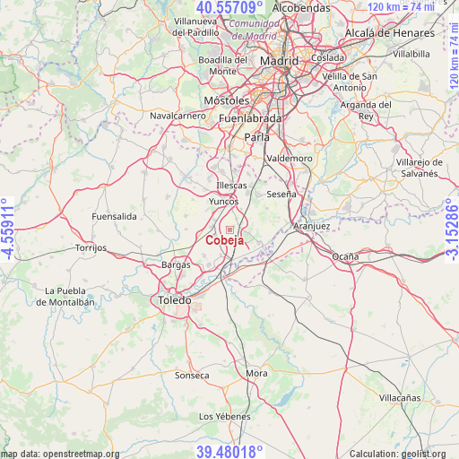
Cobeja GPS coordinates[2]
40° 1' 14.736" North, 3° 51' 21.564" West
| Map corner | latitude | longitude |
|---|---|---|
| Upper-left | 40.55709°, | -4.55911° |
| Center: | 40.02076°, | -3.85599° |
| Lower-right: | 39.48018°, | -3.15286° |
| Map W x H: | 119.7×119.7 km | = 74.4×74.4mi |
| max Lat: | 43.74134° ⇑69.9% North |
| Cobeja: | 40.02076° |
| min Lat: | ⇓30.1% South 27.64134° |
| min Long | Cobeja | max Long |
| -18.00367° | -3.85599° | 4.2899° |
| W 42.4%⇐ | ⇒57.6% E |
Elevation
Elevation of Cobeja is 498 m = 1634 ft, and this is 100 m = 328 ft below average elevation for this country.
| Max E: |
1682 m = 5518 ft | 62.1% |
| Avg. | 598 m = 1962 ft | |
| Cobeja | 498 m = 1634 ft | |
Min E: |
0 m = 0 ft | 37.9% |
See also: Spain elevation on elevation.city.
Geographical zone
Cobeja is located in North temperate zone (between Tropic of Cancer and the Arctic Circle). Distance of this Northern Tropic circle is 1844 km =1145.8 mi to South.| Distance of | km | miles | from Cobeja |
|---|---|---|---|
| North Pole | 5557.2 | 3453.1 | to North |
| Arctic Circle | 2951.3 | 1833.9 | to North |
| Tropic Cancer | 1844 | 1145.8 | to South |
| Equator | 4449.9 | 2765 | to South |


Nearby cities:
15 places around Cobeja: (largest is in red/bold)
• Añover de Tajo
8.5 km =5.3 mi,  114°
114°
• Borox
11.3 km =7 mi,  62°
62°
• Cabañas de la Sagra
7.8 km =4.8 mi,  257°
257°
• Cedillo del Condado
11.6 km =7.2 mi,  331°
331°
• Esquivias
12 km =7.5 mi,  39°
39°
• Illescas
11.3 km =7 mi,  3°
3°
• La Alameda de la Sagra
5.5 km =3.4 mi,  100°
100°
• Magán
9.2 km =5.7 mi,  224°
224°
• Mocejón
10.4 km =6.5 mi,  209°
209°
• Numancia de la Sagra
5.9 km =3.7 mi, 3°
• Pantoja
3.2 km =2 mi, 38°
• Villaseca de la Sagra
6.9 km =4.3 mi,  199°
199°
• Yeles
11.9 km =7.4 mi,  21°
21°
• Yuncler
4.3 km =2.7 mi,  300°
300°
• Yuncos
7.4 km =4.6 mi,  349°
349°
Sources, notices
• [Note1] Compared only with cities in Spain existing in our database
• [Src1] Map data: © OpenStreetMap contributors (CC-BY-SA)
• [Src2] Other city data from geonames.org with taken over terms of usage.
• [Src3] Geographical zone / Annual Mean Temperature by Robert A. Rohde @ Wikipedia
