Recas geodata
Recas (Castille-La Mancha) is a seat of a third-order administrative division; located in Spain in Europe/Madrid (GMT+2) time zone. With population of 2,877 people, there are 1763 cities with bigger population in this country. Compared to other cities in Spain, 69.5% of cities are located further ↑North; 59.6% of cities are located further →East and 56.7% of cities have higher elevation than Recas. Note1


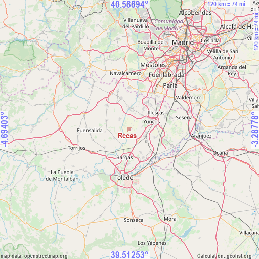
Recas GPS coordinates[2]
40° 3' 10.296" North, 3° 59' 27.24" West
| Map corner | latitude | longitude |
|---|---|---|
| Upper-left | 40.58894°, | -4.69403° |
| Center: | 40.05286°, | -3.9909° |
| Lower-right: | 39.51253°, | -3.28778° |
| Map W x H: | 119.7×119.7 km | = 74.4×74.4mi |
| max Lat: | 43.74134° ⇑69.5% North |
| Recas: | 40.05286° |
| min Lat: | ⇓30.5% South 27.64134° |
| min Long | Recas | max Long |
| -18.00367° | -3.9909° | 4.2899° |
| W 40.4%⇐ | ⇒59.6% E |
Elevation
Elevation of Recas is 571 m = 1873 ft, and this is 27 m = 89 ft below average elevation for this country.
| Max E: |
1682 m = 5518 ft | 56.7% |
| Avg. | 598 m = 1962 ft | |
| Recas | 571 m = 1873 ft | |
Min E: |
0 m = 0 ft | 43.3% |
See also: Spain elevation on elevation.city.
Geographical zone
Recas is located in North temperate zone (between Tropic of Cancer and the Arctic Circle). Distance of this Northern Tropic circle is 1847.5 km =1148 mi to South.| Distance of | km | miles | from Recas |
|---|---|---|---|
| North Pole | 5553.6 | 3450.8 | to North |
| Arctic Circle | 2947.7 | 1831.6 | to North |
| Tropic Cancer | 1847.5 | 1148 | to South |
| Equator | 4453.5 | 2767.3 | to South |


Nearby cities:
15 places around Recas: (largest is in red/bold)
• Arcicóllar
10.7 km =6.6 mi,  271°
271°
• Cabañas de la Sagra
6.5 km =4 mi,  143°
143°
• Camarena
11.8 km =7.3 mi,  292°
292°
• Camarenilla
8.3 km =5.2 mi,  241°
241°
• Cedillo del Condado
8.9 km =5.5 mi,  41°
41°
• Chozas de Canales
6.9 km =4.3 mi,  319°
319°
• Cobeja
12 km =7.5 mi,  107°
107°
• El Viso de San Juan
11.6 km =7.2 mi,  32°
32°
• Lominchar
4.7 km =2.9 mi, 25°
• Magán
11.4 km =7.1 mi,  153°
153°
• Numancia de la Sagra
12.1 km =7.5 mi,  78°
78°
• Olías del Rey
12.1 km =7.5 mi,  178°
178°
• Palomeque
7.8 km =4.8 mi,  17°
17°
• Yuncler
7.9 km =4.9 mi,  99°
99°
• Yuncos
10.8 km =6.7 mi,  70°
70°
Sources, notices
• [Note1] Compared only with cities in Spain existing in our database
• [Src1] Map data: © OpenStreetMap contributors (CC-BY-SA)
• [Src2] Other city data from geonames.org with taken over terms of usage.
• [Src3] Geographical zone / Annual Mean Temperature by Robert A. Rohde @ Wikipedia
