Luintra geodata
Luintra (Galicia) is a populated place; located in Spain in Europe/Madrid (GMT+2) time zone. With population of 1,283 people, there are 2656 cities with bigger population in this country. Compared to other cities in Spain, 85.1% of cities are located further ↓South; 95.8% of cities are located further →East and 52% of cities have higher elevation than Luintra. Note1
Administrative division(s):
- Level 1: Galicia
- Level 2: Provincia de Ourense
- Level 3: Nogueira de Ramuín


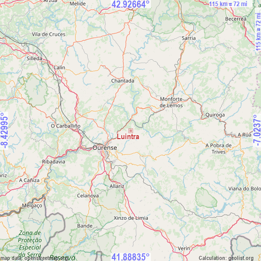
Luintra GPS coordinates[2]
42° 24' 34.704" North, 7° 43' 36.552" West
| Map corner | latitude | longitude |
|---|---|---|
| Upper-left | 42.92664°, | -8.42995° |
| Center: | 42.40964°, | -7.72682° |
| Lower-right: | 41.88835°, | -7.0237° |
| Map W x H: | 115.4×115.4 km | = 71.7×71.7mi |
| max Lat: | 43.74134° ⇑14.9% North |
| Luintra: | 42.40964° |
| min Lat: | ⇓85.1% South 27.64134° |
| min Long | Luintra | max Long |
| -18.00367° | -7.72682° | 4.2899° |
| W 4.2%⇐ | ⇒95.8% E |
Elevation
Elevation of Luintra is 637 m = 2090 ft, and this is 39 m = 128 ft above average elevation for this country.
| Max E: |
1682 m = 5518 ft | 52% |
| Luintra | 637 m 2090 ft | |
| Avg. | 598 m = 1962 ft | |
Min E: |
0 m = 0 ft | 48% |
See also: Spain elevation on elevation.city.
Geographical zone
Luintra is located in North temperate zone (between Tropic of Cancer and the Arctic Circle). Distance of this Northern Tropic circle is 2109.6 km =1310.8 mi to South.| Distance of | km | miles | from Luintra |
|---|---|---|---|
| North Pole | 5291.6 | 3288 | to North |
| Arctic Circle | 2685.7 | 1668.8 | to North |
| Tropic Cancer | 2109.6 | 1310.8 | to South |
| Equator | 4715.5 | 2930.1 | to South |


Nearby cities:
15 places around Luintra: (largest is in red/bold)
• Amoeiro
18.3 km =11.4 mi,  272°
272°
• Baños de Molgas
19.2 km =11.9 mi,  166°
166°
• Carballedo
15 km =9.3 mi,  326°
326°
• Coles
8.8 km =5.5 mi,  263°
263°
• Esgos
9.7 km =6 mi, 165°
• Lobios
16 km =9.9 mi,  90°
90°
• Maceda
16.8 km =10.4 mi,  158°
158°
• Nogueira de Ramuín
2.1 km =1.3 mi,  293°
293°
• Ourense
13.9 km =8.6 mi,  234°
234°
• Pantón
15.8 km =9.8 mi,  41°
41°
• Pereiro de Aguiar
9.4 km =5.8 mi,  220°
220°
• Sober
12.9 km =8 mi,  63°
63°
• Taboadela
20.3 km =12.6 mi,  203°
203°
• Vilamarín
14.8 km =9.2 mi, 294°
• Vilarnaz
11.2 km =7 mi, 264°
Sources, notices
• [Note1] Compared only with cities in Spain existing in our database
• [Src1] Map data: © OpenStreetMap contributors (CC-BY-SA)
• [Src2] Other city data from geonames.org with taken over terms of usage.
• [Src3] Geographical zone / Annual Mean Temperature by Robert A. Rohde @ Wikipedia
