Olot geodata
Olot (Catalonia) is a seat of a third-order administrative division; located in Spain in Europe/Madrid (GMT+2) time zone. With population of 33,524 people, there are 268 cities with bigger population in this country. Compared to other cities in Spain, 78.8% of cities are located further ↓South; 96.4% of cities are located further ←West and 66.7% of cities have higher elevation than Olot. Note1


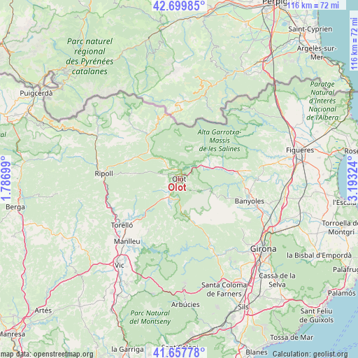
Olot GPS coordinates[2]
42° 10' 51.456" North, 2° 29' 24.432" East
| Map corner | latitude | longitude |
|---|---|---|
| Upper-left | 42.69985°, | 1.78699° |
| Center: | 42.18096°, | 2.49012° |
| Lower-right: | 41.65778°, | 3.19324° |
| Map W x H: | 115.9×115.9 km | = 72×72mi |
| max Lat: | 43.74134° ⇑21.2% North |
| Olot: | 42.18096° |
| min Lat: | ⇓78.8% South 27.64134° |
| min Long | Olot | max Long |
| -18.00367° | 2.49012° | 4.2899° |
| W 96.4%⇐ | ⇒3.6% E |
Elevation
Elevation of Olot is 438 m = 1437 ft, and this is 160 m = 525 ft below average elevation for this country.
| Max E: |
1682 m = 5518 ft | 66.7% |
| Avg. | 598 m = 1962 ft | |
| Olot | 438 m = 1437 ft | |
Min E: |
0 m = 0 ft | 33.3% |
See also: Spain elevation on elevation.city.
Geographical zone
Olot is located in North temperate zone (between Tropic of Cancer and the Arctic Circle). Distance of this Northern Tropic circle is 2084.2 km =1295.1 mi to South.| Distance of | km | miles | from Olot |
|---|---|---|---|
| North Pole | 5317 | 3303.8 | to North |
| Arctic Circle | 2711.1 | 1684.6 | to North |
| Tropic Cancer | 2084.2 | 1295.1 | to South |
| Equator | 4690.1 | 2914.3 | to South |


Nearby cities:
15 places around Olot: (largest is in red/bold)
• Argelaguer
13.1 km =8.1 mi,  72°
72°
• Castellfollit de la Roca
6.5 km =4 mi,  48°
48°
• Montagut
10.3 km =6.4 mi,  58°
58°
• Sant Aniol de Finestres
12.9 km =8 mi,  141°
141°
• Sant Cristòfol de les Fonts
1.5 km =0.9 mi,  148°
148°
• Sant Esteve d'en Bas
7.5 km =4.7 mi,  201°
201°
• Sant Feliu de Pallerols
11.7 km =7.3 mi,  172°
172°
• Sant Jaume de Llierca
11.2 km =7 mi, 69°
• Sant Joan les Fonts
3.9 km =2.4 mi,  28°
28°
• Sant Pau de Segúries
13.6 km =8.5 mi,  311°
311°
• Sant Privat d'en Bas
7.5 km =4.7 mi,  242°
242°
• Santa Pau
7.8 km =4.8 mi,  121°
121°
• Tortellà
13.2 km =8.2 mi, 63°
• la Canya
2.8 km =1.7 mi,  11°
11°
• les Preses
4.7 km =2.9 mi,  211°
211°
Sources, notices
• [Note1] Compared only with cities in Spain existing in our database
• [Src1] Map data: © OpenStreetMap contributors (CC-BY-SA)
• [Src2] Other city data from geonames.org with taken over terms of usage.
• [Src3] Geographical zone / Annual Mean Temperature by Robert A. Rohde @ Wikipedia
