Tortellà geodata
Tortellà (Catalonia) is a populated place; located in Spain in Europe/Madrid (GMT+2) time zone. With population of 740 people, there are 3327 cities with bigger population in this country. Compared to other cities in Spain, 80.2% of cities are located further ↓South; 96.9% of cities are located further ←West and 76.6% of cities have higher elevation than Tortellà. Note1


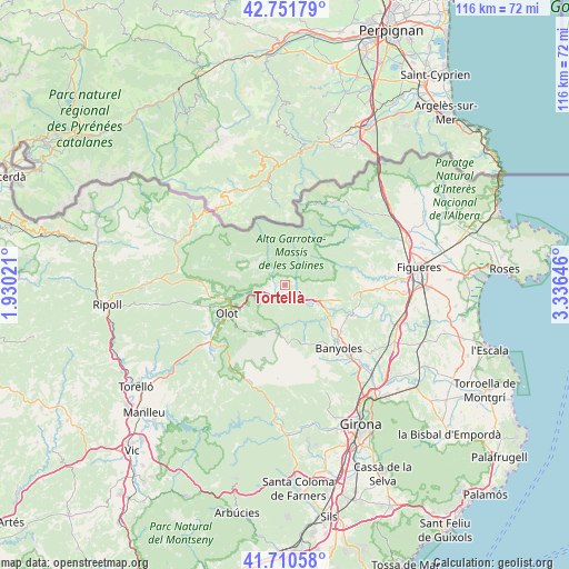
Tortellà GPS coordinates[2]
42° 13' 59.988" North, 2° 37' 59.988" East
| Map corner | latitude | longitude |
|---|---|---|
| Upper-left | 42.75179°, | 1.93021° |
| Center: | 42.23333°, | 2.63333° |
| Lower-right: | 41.71058°, | 3.33646° |
| Map W x H: | 115.8×115.8 km | = 72×72mi |
| max Lat: | 43.74134° ⇑19.8% North |
| Tortellà: | 42.23333° |
| min Lat: | ⇓80.2% South 27.64134° |
| min Long | Tortellà | max Long |
| -18.00367° | 2.63333° | 4.2899° |
| W 96.9%⇐ | ⇒3.1% E |
Elevation
Elevation of Tortellà is 277 m = 909 ft, and this is 321 m = 1053 ft below average elevation for this country.
| Max E: |
1682 m = 5518 ft | 76.6% |
| Avg. | 598 m = 1962 ft | |
| Tortellà | 277 m = 909 ft | |
Min E: |
0 m = 0 ft | 23.4% |
See also: Spain elevation on elevation.city.
Geographical zone
Tortellà is located in North temperate zone (between Tropic of Cancer and the Arctic Circle). Distance of this Northern Tropic circle is 2090 km =1298.7 mi to South.| Distance of | km | miles | from Tortellà |
|---|---|---|---|
| North Pole | 5311.2 | 3300.2 | to North |
| Arctic Circle | 2705.3 | 1681 | to North |
| Tropic Cancer | 2090 | 1298.7 | to South |
| Equator | 4695.9 | 2917.9 | to South |


Nearby cities:
15 places around Tortellà: (largest is in red/bold)
• Argelaguer
2.1 km =1.3 mi,  160°
160°
• Besalú
6.7 km =4.2 mi,  125°
125°
• Beuda
6.3 km =3.9 mi,  86°
86°
• Castellfollit de la Roca
7.1 km =4.4 mi,  257°
257°
• Mieres
12.3 km =7.6 mi,  178°
178°
• Montagut
3.1 km =1.9 mi, 263°
• Olot
13.2 km =8.2 mi,  243°
243°
• Sales de Llierca
1.4 km =0.9 mi, 90°
• Sant Cristòfol de les Fonts
13.1 km =8.1 mi, 237°
• Sant Ferriol
4.6 km =2.9 mi,  143°
143°
• Sant Jaume de Llierca
2.3 km =1.4 mi,  216°
216°
• Sant Joan les Fonts
10.2 km =6.3 mi, 256°
• Sant Miquel de Campmajor
11.9 km =7.4 mi, 159°
• Santa Pau
11.1 km =6.9 mi,  207°
207°
• la Canya
11.7 km =7.3 mi,  254°
254°
Sources, notices
• [Note1] Compared only with cities in Spain existing in our database
• [Src1] Map data: © OpenStreetMap contributors (CC-BY-SA)
• [Src2] Other city data from geonames.org with taken over terms of usage.
• [Src3] Geographical zone / Annual Mean Temperature by Robert A. Rohde @ Wikipedia
