Argelaguer geodata
Argelaguer (Catalonia) is a seat of a third-order administrative division; located in Spain in Europe/Madrid (GMT+2) time zone. With population of 371 people, there are 4235 cities with bigger population in this country. Compared to other cities in Spain, 79.7% of cities are located further ↓South; 97% of cities are located further ←West and 81.9% of cities have higher elevation than Argelaguer. Note1


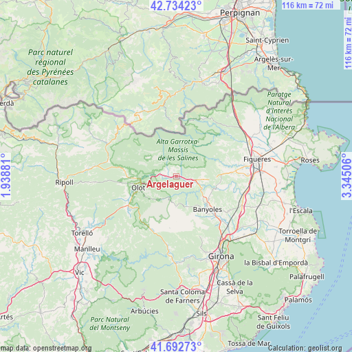
Argelaguer GPS coordinates[2]
42° 12' 56.268" North, 2° 38' 30.948" East
| Map corner | latitude | longitude |
|---|---|---|
| Upper-left | 42.73423°, | 1.93881° |
| Center: | 42.21563°, | 2.64193° |
| Lower-right: | 41.69273°, | 3.34506° |
| Map W x H: | 115.8×115.8 km | = 72×72mi |
| max Lat: | 43.74134° ⇑20.3% North |
| Argelaguer: | 42.21563° |
| min Lat: | ⇓79.7% South 27.64134° |
| min Long | Argelaguer | max Long |
| -18.00367° | 2.64193° | 4.2899° |
| W 97%⇐ | ⇒3% E |
Elevation
Elevation of Argelaguer is 189 m = 620 ft, and this is 409 m = 1342 ft below average elevation for this country.
| Max E: |
1682 m = 5518 ft | 81.9% |
| Avg. | 598 m = 1962 ft | |
| Argelaguer | 189 m = 620 ft | |
Min E: |
0 m = 0 ft | 18.1% |
See also: Spain elevation on elevation.city.
Geographical zone
Argelaguer is located in North temperate zone (between Tropic of Cancer and the Arctic Circle). Distance of this Northern Tropic circle is 2088 km =1297.4 mi to South.| Distance of | km | miles | from Argelaguer |
|---|---|---|---|
| North Pole | 5313.1 | 3301.4 | to North |
| Arctic Circle | 2707.2 | 1682.2 | to North |
| Tropic Cancer | 2088 | 1297.4 | to South |
| Equator | 4693.9 | 2916.7 | to South |


Nearby cities:
15 places around Argelaguer: (largest is in red/bold)
• Besalú
5.1 km =3.2 mi,  111°
111°
• Beuda
6.1 km =3.8 mi,  66°
66°
• Castellfollit de la Roca
7.6 km =4.7 mi,  273°
273°
• Mieres
10.4 km =6.5 mi,  181°
181°
• Montagut
4.1 km =2.5 mi,  293°
293°
• Olot
13.1 km =8.1 mi,  252°
252°
• Sales de Llierca
2.1 km =1.3 mi,  18°
18°
• Sant Cristòfol de les Fonts
12.8 km =8 mi, 246°
• Sant Ferriol
2.7 km =1.7 mi,  130°
130°
• Sant Jaume de Llierca
2.1 km =1.3 mi, 273°
• Sant Joan les Fonts
10.6 km =6.6 mi, 267°
• Sant Miquel de Campmajor
9.8 km =6.1 mi,  159°
159°
• Santa Pau
9.8 km =6.1 mi,  216°
216°
• Tortellà
2.1 km =1.3 mi,  340°
340°
• la Canya
12 km =7.5 mi,  264°
264°
Sources, notices
• [Note1] Compared only with cities in Spain existing in our database
• [Src1] Map data: © OpenStreetMap contributors (CC-BY-SA)
• [Src2] Other city data from geonames.org with taken over terms of usage.
• [Src3] Geographical zone / Annual Mean Temperature by Robert A. Rohde @ Wikipedia
