Montagut geodata
Montagut (Catalonia) is a populated place; located in Spain in Europe/Madrid (GMT+2) time zone. With population of 874 people, there are 3094 cities with bigger population in this country. Compared to other cities in Spain, 80.1% of cities are located further ↓South; 96.8% of cities are located further ←West and 76.5% of cities have higher elevation than Montagut. Note1


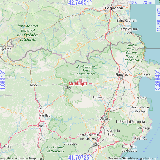
Montagut GPS coordinates[2]
42° 13' 48.108" North, 2° 35' 46.716" East
| Map corner | latitude | longitude |
|---|---|---|
| Upper-left | 42.74851°, | 1.89318° |
| Center: | 42.23003°, | 2.59631° |
| Lower-right: | 41.70725°, | 3.29943° |
| Map W x H: | 115.8×115.8 km | = 72×72mi |
| max Lat: | 43.74134° ⇑19.9% North |
| Montagut: | 42.23003° |
| min Lat: | ⇓80.1% South 27.64134° |
| min Long | Montagut | max Long |
| -18.00367° | 2.59631° | 4.2899° |
| W 96.8%⇐ | ⇒3.2% E |
Elevation
Elevation of Montagut is 278 m = 912 ft, and this is 320 m = 1050 ft below average elevation for this country.
| Max E: |
1682 m = 5518 ft | 76.5% |
| Avg. | 598 m = 1962 ft | |
| Montagut | 278 m = 912 ft | |
Min E: |
0 m = 0 ft | 23.5% |
See also: Spain elevation on elevation.city.
Geographical zone
Montagut is located in North temperate zone (between Tropic of Cancer and the Arctic Circle). Distance of this Northern Tropic circle is 2089.6 km =1298.4 mi to South.| Distance of | km | miles | from Montagut |
|---|---|---|---|
| North Pole | 5311.5 | 3300.4 | to North |
| Arctic Circle | 2705.6 | 1681.2 | to North |
| Tropic Cancer | 2089.6 | 1298.4 | to South |
| Equator | 4695.5 | 2917.6 | to South |


Nearby cities:
15 places around Montagut: (largest is in red/bold)
• Argelaguer
4.1 km =2.5 mi,  113°
113°
• Besalú
9.2 km =5.7 mi, 112°
• Beuda
9.3 km =5.8 mi,  85°
85°
• Castellfollit de la Roca
4 km =2.5 mi,  253°
253°
• Mieres
12.5 km =7.8 mi,  163°
163°
• Olot
10.3 km =6.4 mi,  238°
238°
• Sales de Llierca
4.4 km =2.7 mi, 85°
• Sant Cristòfol de les Fonts
10.4 km =6.5 mi,  229°
229°
• Sant Ferriol
6.7 km =4.2 mi,  119°
119°
• Sant Jaume de Llierca
2.2 km =1.4 mi,  131°
131°
• Sant Joan les Fonts
7.2 km =4.5 mi, 253°
• Sant Miquel de Campmajor
12.9 km =8 mi,  146°
146°
• Santa Pau
9.8 km =6.1 mi,  192°
192°
• Tortellà
3.1 km =1.9 mi,  83°
83°
• la Canya
8.6 km =5.3 mi, 251°
Sources, notices
• [Note1] Compared only with cities in Spain existing in our database
• [Src1] Map data: © OpenStreetMap contributors (CC-BY-SA)
• [Src2] Other city data from geonames.org with taken over terms of usage.
• [Src3] Geographical zone / Annual Mean Temperature by Robert A. Rohde @ Wikipedia
