Bello geodata
Bello (Aragon) is a seat of a third-order administrative division; located in Spain in Europe/Madrid (GMT+2) time zone. With population of 346 people, there are 4324 cities with bigger population in this country. Compared to other cities in Spain, 53.3% of cities are located further ↑North; 73% of cities are located further ←West and 88.6% of cities have lower elevation than Bello. Note1


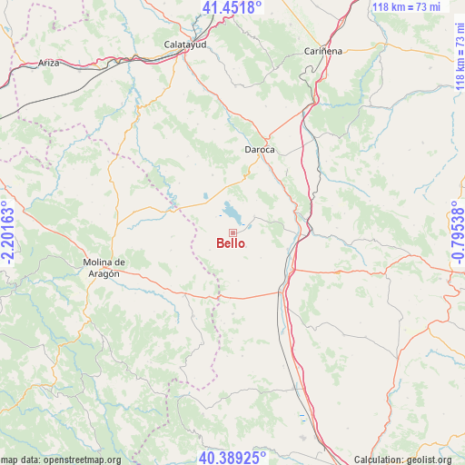
Bello GPS coordinates[2]
40° 55' 21.576" North, 1° 29' 54.6" West
| Map corner | latitude | longitude |
|---|---|---|
| Upper-left | 41.4518°, | -2.20163° |
| Center: | 40.92266°, | -1.4985° |
| Lower-right: | 40.38925°, | -0.79538° |
| Map W x H: | 118.1×118.1 km | = 73.4×73.4mi |
| max Lat: | 43.74134° ⇑53.3% North |
| Bello: | 40.92266° |
| min Lat: | ⇓46.7% South 27.64134° |
| min Long | Bello | max Long |
| -18.00367° | -1.4985° | 4.2899° |
| W 73%⇐ | ⇒27% E |
Elevation
Elevation of Bello is 1007 m = 3304 ft, and this is 409 m = 1342 ft above average elevation for this country.
| Max E: |
1682 m = 5518 ft | 11.4% |
| Bello | 1007 m 3304 ft | |
| Avg. | 598 m = 1962 ft | |
Min E: |
0 m = 0 ft | 88.6% |
See also: Spain elevation on elevation.city.
Geographical zone
Bello is located in North temperate zone (between Tropic of Cancer and the Arctic Circle). Distance of this Northern Tropic circle is 1944.3 km =1208.1 mi to South.| Distance of | km | miles | from Bello |
|---|---|---|---|
| North Pole | 5456.9 | 3390.8 | to North |
| Arctic Circle | 2851 | 1771.5 | to North |
| Tropic Cancer | 1944.3 | 1208.1 | to South |
| Equator | 4550.2 | 2827.4 | to South |


Nearby cities:
15 places around Bello: (largest is in red/bold)
• Blancas
12.2 km =7.6 mi,  173°
173°
• Burbáguena
17.1 km =10.6 mi,  51°
51°
• Calamocha
16.9 km =10.5 mi,  91°
91°
• Campillo de Dueñas
16.3 km =10.1 mi,  254°
254°
• Castejón de Tornos
10.2 km =6.3 mi,  35°
35°
• Fuentes Claras
16.2 km =10.1 mi,  113°
113°
• Gallocanta
8.2 km =5.1 mi,  354°
354°
• Odón
7.2 km =4.5 mi,  233°
233°
• Pozuel del Campo
16.8 km =10.4 mi,  182°
182°
• Santed
12.2 km =7.6 mi,  355°
355°
• Tornos
7 km =4.3 mi, 51°
• Torralba de los Sisones
4.9 km =3 mi,  136°
136°
• Torrijo del Campo
17.3 km =10.7 mi,  128°
128°
• Used
15.6 km =9.7 mi,  340°
340°
• Val de San Martín
15.6 km =9.7 mi,  15°
15°
Sources, notices
• [Note1] Compared only with cities in Spain existing in our database
• [Src1] Map data: © OpenStreetMap contributors (CC-BY-SA)
• [Src2] Other city data from geonames.org with taken over terms of usage.
• [Src3] Geographical zone / Annual Mean Temperature by Robert A. Rohde @ Wikipedia
