Blancas geodata
Blancas (Aragon) is a seat of a third-order administrative division; located in Spain in Europe/Madrid (GMT+2) time zone. With population of 165 people, there are 5307 cities with bigger population in this country. Compared to other cities in Spain, 55.9% of cities are located further ↑North; 73.1% of cities are located further ←West and 91.2% of cities have lower elevation than Blancas. Note1


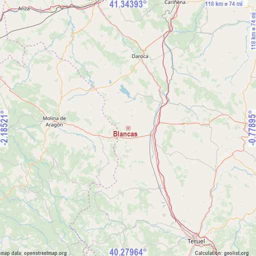
Blancas GPS coordinates[2]
40° 48' 50.112" North, 1° 28' 55.488" West
| Map corner | latitude | longitude |
|---|---|---|
| Upper-left | 41.34393°, | -2.18521° |
| Center: | 40.81392°, | -1.48208° |
| Lower-right: | 40.27964°, | -0.77895° |
| Map W x H: | 118.3×118.3 km | = 73.5×73.5mi |
| max Lat: | 43.74134° ⇑55.9% North |
| Blancas: | 40.81392° |
| min Lat: | ⇓44.1% South 27.64134° |
| min Long | Blancas | max Long |
| -18.00367° | -1.48208° | 4.2899° |
| W 73.1%⇐ | ⇒26.9% E |
Elevation
Elevation of Blancas is 1050 m = 3445 ft, and this is 452 m = 1483 ft above average elevation for this country.
| Max E: |
1682 m = 5518 ft | 8.8% |
| Blancas | 1050 m 3445 ft | |
| Avg. | 598 m = 1962 ft | |
Min E: |
0 m = 0 ft | 91.2% |
See also: Spain elevation on elevation.city.
Geographical zone
Blancas is located in North temperate zone (between Tropic of Cancer and the Arctic Circle). Distance of this Northern Tropic circle is 1932.2 km =1200.6 mi to South.| Distance of | km | miles | from Blancas |
|---|---|---|---|
| North Pole | 5469 | 3398.3 | to North |
| Arctic Circle | 2863.1 | 1779 | to North |
| Tropic Cancer | 1932.2 | 1200.6 | to South |
| Equator | 4538.1 | 2819.8 | to South |


Nearby cities:
15 places around Blancas: (largest is in red/bold)
• Bello
12.2 km =7.6 mi,  353°
353°
• Caminreal
13.6 km =8.5 mi,  78°
78°
• Fuentes Claras
14.5 km =9 mi,  67°
67°
• Hombrados
17.2 km =10.7 mi,  265°
265°
• Monreal del Campo
11 km =6.8 mi,  105°
105°
• Odón
10.6 km =6.6 mi,  317°
317°
• Ojos Negros
8.6 km =5.3 mi,  189°
189°
• Pozuel del Campo
5.1 km =3.2 mi,  202°
202°
• Setiles
14.4 km =8.9 mi,  232°
232°
• Tordesilos
18.5 km =11.5 mi,  210°
210°
• Tornos
16.9 km =10.5 mi,  13°
13°
• Torralba de los Sisones
8.8 km =5.5 mi, 12°
• Torrijo del Campo
12.2 km =7.6 mi, 83°
• Villafranca del Campo
17.4 km =10.8 mi,  139°
139°
• Villar del Salz
14.7 km =9.1 mi, 185°
Sources, notices
• [Note1] Compared only with cities in Spain existing in our database
• [Src1] Map data: © OpenStreetMap contributors (CC-BY-SA)
• [Src2] Other city data from geonames.org with taken over terms of usage.
• [Src3] Geographical zone / Annual Mean Temperature by Robert A. Rohde @ Wikipedia
