Gallocanta geodata
Gallocanta (Aragon) is a seat of a third-order administrative division; located in Spain in Europe/Madrid (GMT+2) time zone. With population of 148 people, there are 5444 cities with bigger population in this country. Compared to other cities in Spain, 51.7% of cities are located further ↑North; 72.8% of cities are located further ←West and 89.1% of cities have lower elevation than Gallocanta. Note1


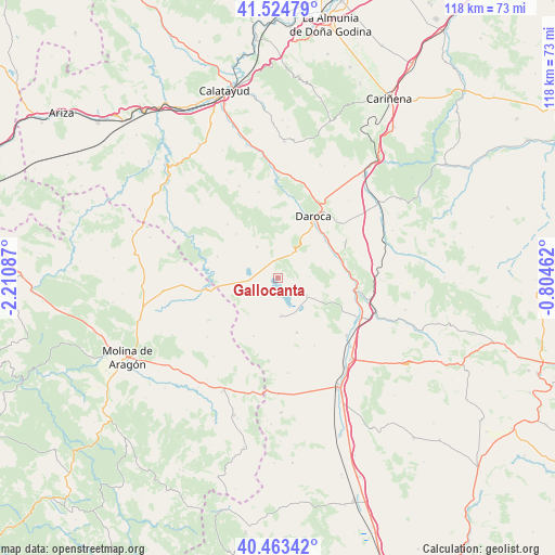
Gallocanta GPS coordinates[2]
40° 59' 46.464" North, 1° 30' 27.864" West
| Map corner | latitude | longitude |
|---|---|---|
| Upper-left | 41.52479°, | -2.21087° |
| Center: | 40.99624°, | -1.50774° |
| Lower-right: | 40.46342°, | -0.80462° |
| Map W x H: | 118×118 km | = 73.3×73.3mi |
| max Lat: | 43.74134° ⇑51.7% North |
| Gallocanta: | 40.99624° |
| min Lat: | ⇓48.3% South 27.64134° |
| min Long | Gallocanta | max Long |
| -18.00367° | -1.50774° | 4.2899° |
| W 72.8%⇐ | ⇒27.2% E |
Elevation
Elevation of Gallocanta is 1017 m = 3337 ft, and this is 419 m = 1375 ft above average elevation for this country.
| Max E: |
1682 m = 5518 ft | 10.9% |
| Gallocanta | 1017 m 3337 ft | |
| Avg. | 598 m = 1962 ft | |
Min E: |
0 m = 0 ft | 89.1% |
See also: Spain elevation on elevation.city.
Geographical zone
Gallocanta is located in North temperate zone (between Tropic of Cancer and the Arctic Circle). Distance of this Northern Tropic circle is 1952.4 km =1213.2 mi to South.| Distance of | km | miles | from Gallocanta |
|---|---|---|---|
| North Pole | 5448.7 | 3385.7 | to North |
| Arctic Circle | 2842.8 | 1766.4 | to North |
| Tropic Cancer | 1952.4 | 1213.2 | to South |
| Equator | 4558.4 | 2832.5 | to South |


Nearby cities:
15 places around Gallocanta: (largest is in red/bold)
• Balconchán
10.9 km =6.8 mi,  21°
21°
• Bello
8.2 km =5.1 mi,  174°
174°
• Báguena
13.6 km =8.5 mi,  68°
68°
• Castejón de Tornos
6.7 km =4.2 mi,  89°
89°
• Odón
13.4 km =8.3 mi,  202°
202°
• Orcajo
12.7 km =7.9 mi,  6°
6°
• San Martín del Río
12.8 km =8 mi,  52°
52°
• Santed
4 km =2.5 mi,  356°
356°
• Tornos
7.3 km =4.5 mi,  121°
121°
• Torralba de los Frailes
13.6 km =8.5 mi,  289°
289°
• Torralba de los Sisones
12.4 km =7.7 mi,  160°
160°
• Used
7.9 km =4.9 mi,  326°
326°
• Val de San Martín
8.4 km =5.2 mi,  35°
35°
• Valdehorna
11 km =6.8 mi, 39°
• Villanueva de Jiloca
13.3 km =8.3 mi, 48°
Sources, notices
• [Note1] Compared only with cities in Spain existing in our database
• [Src1] Map data: © OpenStreetMap contributors (CC-BY-SA)
• [Src2] Other city data from geonames.org with taken over terms of usage.
• [Src3] Geographical zone / Annual Mean Temperature by Robert A. Rohde @ Wikipedia
