Santed geodata
Santed (Aragon) is a seat of a third-order administrative division; located in Spain in Europe/Madrid (GMT+2) time zone. With population of 75 people, there are 6194 cities with bigger population in this country. Compared to other cities in Spain, 50.8% of cities are located further ↑North; 72.8% of cities are located further ←West and 91.8% of cities have lower elevation than Santed. Note1


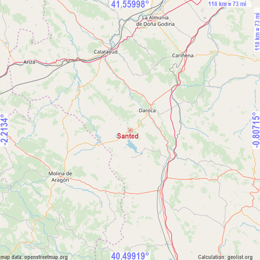
Santed GPS coordinates[2]
41° 1' 54.192" North, 1° 30' 37.008" West
| Map corner | latitude | longitude |
|---|---|---|
| Upper-left | 41.55998°, | -2.2134° |
| Center: | 41.03172°, | -1.51028° |
| Lower-right: | 40.49919°, | -0.80715° |
| Map W x H: | 117.9×117.9 km | = 73.3×73.3mi |
| max Lat: | 43.74134° ⇑50.8% North |
| Santed: | 41.03172° |
| min Lat: | ⇓49.2% South 27.64134° |
| min Long | Santed | max Long |
| -18.00367° | -1.51028° | 4.2899° |
| W 72.8%⇐ | ⇒27.2% E |
Elevation
Elevation of Santed is 1064 m = 3491 ft, and this is 466 m = 1529 ft above average elevation for this country.
| Max E: |
1682 m = 5518 ft | 8.2% |
| Santed | 1064 m 3491 ft | |
| Avg. | 598 m = 1962 ft | |
Min E: |
0 m = 0 ft | 91.8% |
See also: Spain elevation on elevation.city.
Geographical zone
Santed is located in North temperate zone (between Tropic of Cancer and the Arctic Circle). Distance of this Northern Tropic circle is 1956.4 km =1215.7 mi to South.| Distance of | km | miles | from Santed |
|---|---|---|---|
| North Pole | 5444.8 | 3383.2 | to North |
| Arctic Circle | 2838.9 | 1764 | to North |
| Tropic Cancer | 1956.4 | 1215.7 | to South |
| Equator | 4562.3 | 2834.9 | to South |


Nearby cities:
15 places around Santed: (largest is in red/bold)
• Balconchán
7.5 km =4.7 mi,  34°
34°
• Bello
12.2 km =7.6 mi,  175°
175°
• Báguena
12.8 km =8 mi,  84°
84°
• Castejón de Tornos
7.9 km =4.9 mi,  119°
119°
• Cubel
12.8 km =8 mi,  303°
303°
• Daroca
12.2 km =7.6 mi,  40°
40°
• Gallocanta
4 km =2.5 mi, 176°
• Orcajo
8.9 km =5.5 mi,  11°
11°
• San Martín del Río
11 km =6.8 mi,  69°
69°
• Tornos
10.1 km =6.3 mi,  140°
140°
• Torralba de los Frailes
12.6 km =7.8 mi,  272°
272°
• Used
4.9 km =3 mi, 302°
• Val de San Martín
5.9 km =3.7 mi,  60°
60°
• Valdehorna
8.6 km =5.3 mi, 57°
• Villanueva de Jiloca
11.3 km =7 mi, 63°
Sources, notices
• [Note1] Compared only with cities in Spain existing in our database
• [Src1] Map data: © OpenStreetMap contributors (CC-BY-SA)
• [Src2] Other city data from geonames.org with taken over terms of usage.
• [Src3] Geographical zone / Annual Mean Temperature by Robert A. Rohde @ Wikipedia
