Navas del Rey geodata
Navas del Rey (Madrid) is a seat of a third-order administrative division; located in Spain in Europe/Madrid (GMT+2) time zone. With population of 2,342 people, there are 1977 cities with bigger population in this country. Compared to other cities in Spain, 64.3% of cities are located further ↑North; 63.2% of cities are located further →East and 56.4% of cities have lower elevation than Navas del Rey. Note1


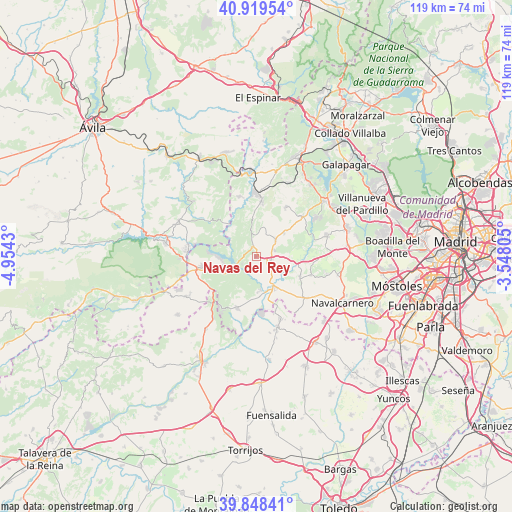
Navas del Rey GPS coordinates[2]
40° 23' 9.96" North, 4° 15' 4.212" West
| Map corner | latitude | longitude |
|---|---|---|
| Upper-left | 40.91954°, | -4.9543° |
| Center: | 40.3861°, | -4.25117° |
| Lower-right: | 39.84841°, | -3.54805° |
| Map W x H: | 119.1×119.1 km | = 74×74mi |
| max Lat: | 43.74134° ⇑64.3% North |
| Navas del Rey: | 40.3861° |
| min Lat: | ⇓35.7% South 27.64134° |
| min Long | Navas del Rey | max Long |
| -18.00367° | -4.25117° | 4.2899° |
| W 36.8%⇐ | ⇒63.2% E |
Elevation
Elevation of Navas del Rey is 719 m = 2359 ft, and this is 121 m = 397 ft above average elevation for this country.
| Max E: |
1682 m = 5518 ft | 43.6% |
| Navas del Rey | 719 m 2359 ft | |
| Avg. | 598 m = 1962 ft | |
Min E: |
0 m = 0 ft | 56.4% |
See also: Spain elevation on elevation.city.
Geographical zone
Navas del Rey is located in North temperate zone (between Tropic of Cancer and the Arctic Circle). Distance of this Northern Tropic circle is 1884.6 km =1171 mi to South.| Distance of | km | miles | from Navas del Rey |
|---|---|---|---|
| North Pole | 5516.5 | 3427.8 | to North |
| Arctic Circle | 2910.7 | 1808.6 | to North |
| Tropic Cancer | 1884.6 | 1171 | to South |
| Equator | 4490.5 | 2790.3 | to South |


Nearby cities:
15 places around Navas del Rey: (largest is in red/bold)
• Aldea del Fresno
8.1 km =5 mi,  149°
149°
• Chapinería
3.6 km =2.2 mi,  102°
102°
• Colmenar del Arroyo
5.8 km =3.6 mi,  50°
50°
• Fresnedillas
13.1 km =8.1 mi,  31°
31°
• Méntrida
17.1 km =10.6 mi,  163°
163°
• Navalagamella
14.2 km =8.8 mi, 49°
• Pelayos de la Presa
7.6 km =4.7 mi,  248°
248°
• Quijorna
17.1 km =10.6 mi,  74°
74°
• Robledo de Chavela
12.8 km =8 mi,  5°
5°
• San Martín de Valdeiglesias
12.8 km =8 mi,  257°
257°
• Valdemaqueda
14.5 km =9 mi,  344°
344°
• Villa del Prado
12.8 km =8 mi,  200°
200°
• Villamanta
15.5 km =9.6 mi,  128°
128°
• Villamantilla
11.6 km =7.2 mi,  117°
117°
• Villanueva de Perales
13.7 km =8.5 mi,  109°
109°
Sources, notices
• [Note1] Compared only with cities in Spain existing in our database
• [Src1] Map data: © OpenStreetMap contributors (CC-BY-SA)
• [Src2] Other city data from geonames.org with taken over terms of usage.
• [Src3] Geographical zone / Annual Mean Temperature by Robert A. Rohde @ Wikipedia
