Fresnedillas geodata
Fresnedillas (Madrid) is a populated place; located in Spain in Europe/Madrid (GMT+2) time zone. With population of 1,131 people, there are 2793 cities with bigger population in this country. Compared to other cities in Spain, 62.1% of cities are located further ↑North; 62.2% of cities are located further →East and 79.9% of cities have lower elevation than Fresnedillas. Note1


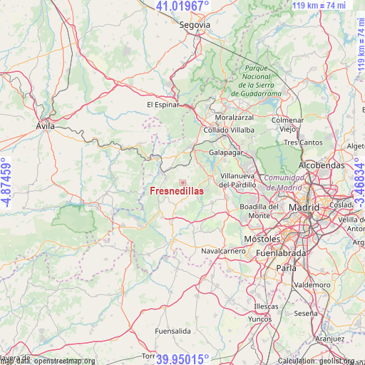
Fresnedillas GPS coordinates[2]
40° 29' 13.344" North, 4° 10' 17.256" West
| Map corner | latitude | longitude |
|---|---|---|
| Upper-left | 41.01967°, | -4.87459° |
| Center: | 40.48704°, | -4.17146° |
| Lower-right: | 39.95015°, | -3.46834° |
| Map W x H: | 118.9×118.9 km | = 73.9×73.9mi |
| max Lat: | 43.74134° ⇑62.1% North |
| Fresnedillas: | 40.48704° |
| min Lat: | ⇓37.9% South 27.64134° |
| min Long | Fresnedillas | max Long |
| -18.00367° | -4.17146° | 4.2899° |
| W 37.8%⇐ | ⇒62.2% E |
Elevation
Elevation of Fresnedillas is 896 m = 2940 ft, and this is 298 m = 978 ft above average elevation for this country.
| Max E: |
1682 m = 5518 ft | 20.1% |
| Fresnedillas | 896 m 2940 ft | |
| Avg. | 598 m = 1962 ft | |
Min E: |
0 m = 0 ft | 79.9% |
See also: Spain elevation on elevation.city.
Geographical zone
Fresnedillas is located in North temperate zone (between Tropic of Cancer and the Arctic Circle). Distance of this Northern Tropic circle is 1895.8 km =1178 mi to South.| Distance of | km | miles | from Fresnedillas |
|---|---|---|---|
| North Pole | 5505.3 | 3420.8 | to North |
| Arctic Circle | 2899.4 | 1801.6 | to North |
| Tropic Cancer | 1895.8 | 1178 | to South |
| Equator | 4501.7 | 2797.2 | to South |


Nearby cities:
15 places around Fresnedillas: (largest is in red/bold)
• Chapinería
12.5 km =7.8 mi,  195°
195°
• Colmenar del Arroyo
7.9 km =4.9 mi, 196°
• Colmenarejo
15.4 km =9.6 mi,  57°
57°
• El Escorial
11.2 km =7 mi,  18°
18°
• Navalagamella
4.5 km =2.8 mi,  116°
116°
• Navas del Rey
13.1 km =8.1 mi,  211°
211°
• Peguerinos
16.3 km =10.1 mi,  341°
341°
• Quijorna
11.7 km =7.3 mi, 124°
• Robledo de Chavela
5.7 km =3.5 mi,  285°
285°
• San Lorenzo de El Escorial
11.8 km =7.3 mi,  9°
9°
• Santa María de la Alameda
14 km =8.7 mi,  328°
328°
• Valdemaqueda
11 km =6.8 mi,  284°
284°
• Valdemorillo
9 km =5.6 mi,  80°
80°
• Villanueva de la Cañada
14.8 km =9.2 mi,  107°
107°
• Zarzalejo
6.8 km =4.2 mi,  352°
352°
Sources, notices
• [Note1] Compared only with cities in Spain existing in our database
• [Src1] Map data: © OpenStreetMap contributors (CC-BY-SA)
• [Src2] Other city data from geonames.org with taken over terms of usage.
• [Src3] Geographical zone / Annual Mean Temperature by Robert A. Rohde @ Wikipedia
