Muro de Aguas geodata
Muro de Aguas (La Rioja) is a seat of a third-order administrative division; located in Spain in Europe/Madrid (GMT+2) time zone. With population of 59 people, there are 6361 cities with bigger population in this country. Compared to other cities in Spain, 77.5% of cities are located further ↓South; 65.9% of cities are located further ←West and 79.5% of cities have lower elevation than Muro de Aguas. Note1


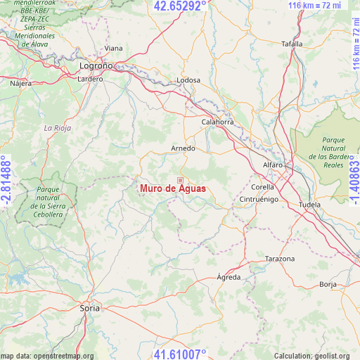
Muro de Aguas GPS coordinates[2]
42° 8' 1.104" North, 2° 6' 42.3" West
| Map corner | latitude | longitude |
|---|---|---|
| Upper-left | 42.65292°, | -2.81488° |
| Center: | 42.13364°, | -2.11175° |
| Lower-right: | 41.61007°, | -1.40863° |
| Map W x H: | 116×116 km | = 72.1×72.1mi |
| max Lat: | 43.74134° ⇑22.5% North |
| Muro de Aguas: | 42.13364° |
| min Lat: | ⇓77.5% South 27.64134° |
| min Long | Muro de Aguas | max Long |
| -18.00367° | -2.11175° | 4.2899° |
| W 65.9%⇐ | ⇒34.1% E |
Elevation
Elevation of Muro de Aguas is 893 m = 2930 ft, and this is 295 m = 968 ft above average elevation for this country.
| Max E: |
1682 m = 5518 ft | 20.5% |
| Muro de Aguas | 893 m 2930 ft | |
| Avg. | 598 m = 1962 ft | |
Min E: |
0 m = 0 ft | 79.5% |
See also: Spain elevation on elevation.city.
Geographical zone
Muro de Aguas is located in North temperate zone (between Tropic of Cancer and the Arctic Circle). Distance of this Northern Tropic circle is 2078.9 km =1291.8 mi to South.| Distance of | km | miles | from Muro de Aguas |
|---|---|---|---|
| North Pole | 5322.2 | 3307.1 | to North |
| Arctic Circle | 2716.4 | 1687.9 | to North |
| Tropic Cancer | 2078.9 | 1291.8 | to South |
| Equator | 4684.8 | 2911 | to South |


Nearby cities:
15 places around Muro de Aguas: (largest is in red/bold)
• Arnedillo
13.5 km =8.4 mi,  310°
310°
• Arnedo
10.5 km =6.5 mi,  4°
4°
• Autol
12.7 km =7.9 mi,  43°
43°
• Bergasa
13.4 km =8.3 mi,  352°
352°
• Bergasillas Bajera
12.9 km =8 mi,  342°
342°
• Cornago
7.8 km =4.8 mi,  169°
169°
• Enciso
13.1 km =8.1 mi,  277°
277°
• Grávalos
9.7 km =6 mi,  106°
106°
• Herce
10 km =6.2 mi,  333°
333°
• Igea
11.1 km =6.9 mi,  131°
131°
• Préjano
8.1 km =5 mi,  316°
316°
• Quel
11.8 km =7.3 mi,  24°
24°
• San Pedro Manrique
15.3 km =9.5 mi,  220°
220°
• Santa Eulalia Bajera
10.7 km =6.6 mi, 322°
• Villarroya
3.5 km =2.2 mi,  95°
95°
Sources, notices
• [Note1] Compared only with cities in Spain existing in our database
• [Src1] Map data: © OpenStreetMap contributors (CC-BY-SA)
• [Src2] Other city data from geonames.org with taken over terms of usage.
• [Src3] Geographical zone / Annual Mean Temperature by Robert A. Rohde @ Wikipedia
