Igea geodata
Igea (La Rioja) is a seat of a third-order administrative division; located in Spain in Europe/Madrid (GMT+2) time zone. With population of 726 people, there are 3356 cities with bigger population in this country. Compared to other cities in Spain, 75.7% of cities are located further ↓South; 67.4% of cities are located further ←West and 56.7% of cities have higher elevation than Igea. Note1


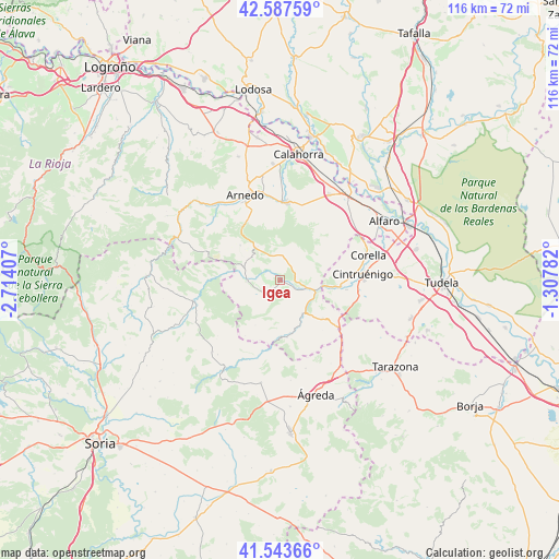
Igea GPS coordinates[2]
42° 4' 3.972" North, 2° 0' 39.384" West
| Map corner | latitude | longitude |
|---|---|---|
| Upper-left | 42.58759°, | -2.71407° |
| Center: | 42.06777°, | -2.01094° |
| Lower-right: | 41.54366°, | -1.30782° |
| Map W x H: | 116.1×116.1 km | = 72.1×72.1mi |
| max Lat: | 43.74134° ⇑24.3% North |
| Igea: | 42.06777° |
| min Lat: | ⇓75.7% South 27.64134° |
| min Long | Igea | max Long |
| -18.00367° | -2.01094° | 4.2899° |
| W 67.4%⇐ | ⇒32.6% E |
Elevation
Elevation of Igea is 570 m = 1870 ft, and this is 28 m = 92 ft below average elevation for this country.
| Max E: |
1682 m = 5518 ft | 56.7% |
| Avg. | 598 m = 1962 ft | |
| Igea | 570 m = 1870 ft | |
Min E: |
0 m = 0 ft | 43.3% |
See also: Spain elevation on elevation.city.
Geographical zone
Igea is located in North temperate zone (between Tropic of Cancer and the Arctic Circle). Distance of this Northern Tropic circle is 2071.6 km =1287.2 mi to South.| Distance of | km | miles | from Igea |
|---|---|---|---|
| North Pole | 5329.6 | 3311.7 | to North |
| Arctic Circle | 2723.7 | 1692.4 | to North |
| Tropic Cancer | 2071.6 | 1287.2 | to South |
| Equator | 4677.5 | 2906.5 | to South |


Nearby cities:
15 places around Igea: (largest is in red/bold)
• Aguilar del Río Alhama
11.8 km =7.3 mi,  172°
172°
• Autol
16.6 km =10.3 mi,  1°
1°
• Cervera del Río Alhama
8.3 km =5.2 mi,  146°
146°
• Cigudosa
15.3 km =9.5 mi,  192°
192°
• Cintruénigo
17.1 km =10.6 mi,  85°
85°
• Cornago
6.9 km =4.3 mi,  266°
266°
• Fitero
12.7 km =7.9 mi,  95°
95°
• Grávalos
4.6 km =2.9 mi,  12°
12°
• Muro de Aguas
11.1 km =6.9 mi,  311°
311°
• Navajún
13.4 km =8.3 mi,  213°
213°
• Quel
18.3 km =11.4 mi,  349°
349°
• San Felices
14.6 km =9.1 mi, 185°
• Valdemadera
10.7 km =6.6 mi, 209°
• Valdeprado
16.6 km =10.3 mi, 209°
• Villarroya
8.5 km =5.3 mi,  325°
325°
Sources, notices
• [Note1] Compared only with cities in Spain existing in our database
• [Src1] Map data: © OpenStreetMap contributors (CC-BY-SA)
• [Src2] Other city data from geonames.org with taken over terms of usage.
• [Src3] Geographical zone / Annual Mean Temperature by Robert A. Rohde @ Wikipedia
