Autol geodata
Autol (La Rioja) is a seat of a third-order administrative division; located in Spain in Europe/Madrid (GMT+2) time zone. With population of 4,002 people, there are 1472 cities with bigger population in this country. Compared to other cities in Spain, 79.7% of cities are located further ↓South; 67.4% of cities are located further ←West and 66.9% of cities have higher elevation than Autol. Note1


Autol GPS coordinates[2]
42° 12' 59.796" North, 2° 0' 18.9" West
| Map corner | latitude | longitude |
|---|---|---|
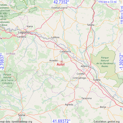
| Upper-left | 42.7352°, | -2.70837° |
| Center: | 42.21661°, | -2.00525° |
| Lower-right: | 41.69372°, | -1.30212° |
| Map W x H: | 115.8×115.8 km | = 72×72mi |
| max Lat: | 43.74134° ⇑20.3% North |
| Autol: | 42.21661° |
| min Lat: | ⇓79.7% South 27.64134° |
| min Long | Autol | max Long |
| -18.00367° | -2.00525° | 4.2899° |
| W 67.4%⇐ | ⇒32.6% E |
Elevation
Elevation of Autol is 434 m = 1424 ft, and this is 164 m = 538 ft below average elevation for this country.
| Max E: |
1682 m = 5518 ft | 66.9% |
| Avg. | 598 m = 1962 ft | |
| Autol | 434 m = 1424 ft | |
Min E: |
0 m = 0 ft | 33.1% |
See also: Spain elevation on elevation.city.
Geographical zone
Autol is located in North temperate zone (between Tropic of Cancer and the Arctic Circle). Distance of this Northern Tropic circle is 2088.1 km =1297.5 mi to South.| Distance of | km | miles | from Autol |
|---|---|---|---|
| North Pole | 5313 | 3301.3 | to North |
| Arctic Circle | 2707.1 | 1682.1 | to North |
| Tropic Cancer | 2088.1 | 1297.5 | to South |
| Equator | 4694 | 2916.7 | to South |


Nearby cities:
15 places around Autol: (largest is in red/bold)
• Aldeanueva de Ebro
9.8 km =6.1 mi,  81°
81°
• Arnedo
8 km =5 mi,  279°
279°
• Azagra
12.7 km =7.9 mi,  43°
43°
• Bergasa
11.2 km =7 mi,  291°
291°
• Bergasillas Bajera
13 km =8.1 mi, 283°
• Calahorra
10.4 km =6.5 mi,  18°
18°
• El Villar de Arnedo
13.8 km =8.6 mi,  327°
327°
• Grávalos
12 km =7.5 mi,  177°
177°
• Herce
13.1 km =8.1 mi,  268°
268°
• Muro de Aguas
12.7 km =7.9 mi,  223°
223°
• Pradejón
14.1 km =8.8 mi,  338°
338°
• Quel
4.1 km =2.5 mi, 290°
• Rincón de Soto
12.8 km =8 mi, 80°
• Tudelilla
13.1 km =8.1 mi,  315°
315°
• Villarroya
10.9 km =6.8 mi,  208°
208°
Sources, notices
• [Note1] Compared only with cities in Spain existing in our database
• [Src1] Map data: © OpenStreetMap contributors (CC-BY-SA)
• [Src2] Other city data from geonames.org with taken over terms of usage.
• [Src3] Geographical zone / Annual Mean Temperature by Robert A. Rohde @ Wikipedia
