Quel geodata
Quel (La Rioja) is a seat of a third-order administrative division; located in Spain in Europe/Madrid (GMT+2) time zone. With population of 2,018 people, there are 2158 cities with bigger population in this country. Compared to other cities in Spain, 80% of cities are located further ↓South; 66.8% of cities are located further ←West and 63.3% of cities have higher elevation than Quel. Note1


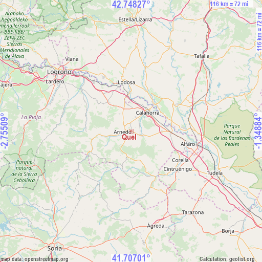
Quel GPS coordinates[2]
42° 13' 47.244" North, 2° 3' 7.056" West
| Map corner | latitude | longitude |
|---|---|---|
| Upper-left | 42.74827°, | -2.75509° |
| Center: | 42.22979°, | -2.05196° |
| Lower-right: | 41.70701°, | -1.34884° |
| Map W x H: | 115.8×115.8 km | = 72×72mi |
| max Lat: | 43.74134° ⇑20% North |
| Quel: | 42.22979° |
| min Lat: | ⇓80% South 27.64134° |
| min Long | Quel | max Long |
| -18.00367° | -2.05196° | 4.2899° |
| W 66.8%⇐ | ⇒33.2% E |
Elevation
Elevation of Quel is 483 m = 1585 ft, and this is 115 m = 377 ft below average elevation for this country.
| Max E: |
1682 m = 5518 ft | 63.3% |
| Avg. | 598 m = 1962 ft | |
| Quel | 483 m = 1585 ft | |
Min E: |
0 m = 0 ft | 36.7% |
See also: Spain elevation on elevation.city.
Geographical zone
Quel is located in North temperate zone (between Tropic of Cancer and the Arctic Circle). Distance of this Northern Tropic circle is 2089.6 km =1298.4 mi to South.| Distance of | km | miles | from Quel |
|---|---|---|---|
| North Pole | 5311.5 | 3300.4 | to North |
| Arctic Circle | 2705.7 | 1681.2 | to North |
| Tropic Cancer | 2089.6 | 1298.4 | to South |
| Equator | 4695.5 | 2917.6 | to South |


Nearby cities:
15 places around Quel: (largest is in red/bold)
• Aldeanueva de Ebro
13.6 km =8.5 mi,  90°
90°
• Arnedo
4 km =2.5 mi,  267°
267°
• Autol
4.1 km =2.5 mi,  110°
110°
• Bergasa
7.1 km =4.4 mi,  291°
291°
• Bergasillas Bajera
8.9 km =5.5 mi,  280°
280°
• Calahorra
11 km =6.8 mi,  40°
40°
• El Villar de Arnedo
10.7 km =6.6 mi,  340°
340°
• Grávalos
14.2 km =8.8 mi,  162°
162°
• Herce
9.5 km =5.9 mi,  259°
259°
• Muro de Aguas
11.8 km =7.3 mi,  204°
204°
• Pradejón
11.7 km =7.3 mi,  353°
353°
• Préjano
11.6 km =7.2 mi,  245°
245°
• Santa Eulalia Bajera
11.7 km =7.3 mi, 258°
• Tudelilla
9.5 km =5.9 mi,  325°
325°
• Villarroya
11.1 km =6.9 mi,  187°
187°
Sources, notices
• [Note1] Compared only with cities in Spain existing in our database
• [Src1] Map data: © OpenStreetMap contributors (CC-BY-SA)
• [Src2] Other city data from geonames.org with taken over terms of usage.
• [Src3] Geographical zone / Annual Mean Temperature by Robert A. Rohde @ Wikipedia
