Enciso geodata
Enciso (La Rioja) is a seat of a third-order administrative division; located in Spain in Europe/Madrid (GMT+2) time zone. With population of 150 people, there are 5428 cities with bigger population in this country. Compared to other cities in Spain, 77.9% of cities are located further ↓South; 63.9% of cities are located further ←West and 68.1% of cities have lower elevation than Enciso. Note1


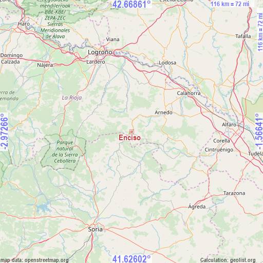
Enciso GPS coordinates[2]
42° 8' 58.056" North, 2° 16' 10.308" West
| Map corner | latitude | longitude |
|---|---|---|
| Upper-left | 42.66861°, | -2.97266° |
| Center: | 42.14946°, | -2.26953° |
| Lower-right: | 41.62602°, | -1.56641° |
| Map W x H: | 115.9×115.9 km | = 72×72mi |
| max Lat: | 43.74134° ⇑22.1% North |
| Enciso: | 42.14946° |
| min Lat: | ⇓77.9% South 27.64134° |
| min Long | Enciso | max Long |
| -18.00367° | -2.26953° | 4.2899° |
| W 63.9%⇐ | ⇒36.1% E |
Elevation
Elevation of Enciso is 800 m = 2625 ft, and this is 202 m = 663 ft above average elevation for this country.
| Max E: |
1682 m = 5518 ft | 31.9% |
| Enciso | 800 m 2625 ft | |
| Avg. | 598 m = 1962 ft | |
Min E: |
0 m = 0 ft | 68.1% |
See also: Spain elevation on elevation.city.
Geographical zone
Enciso is located in North temperate zone (between Tropic of Cancer and the Arctic Circle). Distance of this Northern Tropic circle is 2080.7 km =1292.9 mi to South.| Distance of | km | miles | from Enciso |
|---|---|---|---|
| North Pole | 5320.5 | 3306 | to North |
| Arctic Circle | 2714.6 | 1686.8 | to North |
| Tropic Cancer | 2080.7 | 1292.9 | to South |
| Equator | 4686.6 | 2912.1 | to South |


Nearby cities:
15 places around Enciso: (largest is in red/bold)
• Arnedillo
7.5 km =4.7 mi,  21°
21°
• Arnedo
16.4 km =10.2 mi,  57°
57°
• Bergasa
16.1 km =10 mi,  44°
44°
• Bergasillas Bajera
14 km =8.7 mi, 40°
• Herce
11.2 km =7 mi,  50°
50°
• Hornillos de Cameros
14.1 km =8.8 mi,  298°
298°
• Munilla
4.9 km =3 mi,  334°
334°
• Muro de Aguas
13.1 km =8.1 mi,  97°
97°
• Préjano
8.5 km =5.3 mi, 60°
• Robres del Castillo
14.2 km =8.8 mi,  352°
352°
• San Pedro Manrique
13.8 km =8.6 mi,  166°
166°
• Santa Eulalia Bajera
9.3 km =5.8 mi, 43°
• Villar del Río
10.6 km =6.6 mi,  219°
219°
• Yanguas
7.9 km =4.9 mi,  227°
227°
• Zarzosa
7.1 km =4.4 mi, 301°
Sources, notices
• [Note1] Compared only with cities in Spain existing in our database
• [Src1] Map data: © OpenStreetMap contributors (CC-BY-SA)
• [Src2] Other city data from geonames.org with taken over terms of usage.
• [Src3] Geographical zone / Annual Mean Temperature by Robert A. Rohde @ Wikipedia
