Abanto geodata
Abanto (Aragon) is a seat of a third-order administrative division; located in Spain in Europe/Madrid (GMT+2) time zone. With population of 152 people, there are 5413 cities with bigger population in this country. Compared to other cities in Spain, 51.9% of cities are located further ↓South; 70.7% of cities are located further ←West and 83.2% of cities have lower elevation than Abanto. Note1


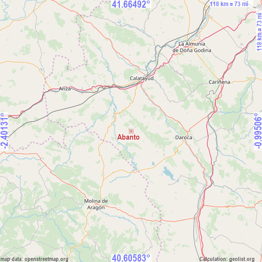
Abanto GPS coordinates[2]
41° 8' 15.036" North, 1° 41' 53.448" West
| Map corner | latitude | longitude |
|---|---|---|
| Upper-left | 41.66492°, | -2.40131° |
| Center: | 41.13751°, | -1.69818° |
| Lower-right: | 40.60583°, | -0.99506° |
| Map W x H: | 117.8×117.8 km | = 73.2×73.2mi |
| max Lat: | 43.74134° ⇑48.1% North |
| Abanto: | 41.13751° |
| min Lat: | ⇓51.9% South 27.64134° |
| min Long | Abanto | max Long |
| -18.00367° | -1.69818° | 4.2899° |
| W 70.7%⇐ | ⇒29.3% E |
Elevation
Elevation of Abanto is 930 m = 3051 ft, and this is 332 m = 1089 ft above average elevation for this country.
| Max E: |
1682 m = 5518 ft | 16.8% |
| Abanto | 930 m 3051 ft | |
| Avg. | 598 m = 1962 ft | |
Min E: |
0 m = 0 ft | 83.2% |
See also: Spain elevation on elevation.city.
Geographical zone
Abanto is located in North temperate zone (between Tropic of Cancer and the Arctic Circle). Distance of this Northern Tropic circle is 1968.1 km =1222.9 mi to South.| Distance of | km | miles | from Abanto |
|---|---|---|---|
| North Pole | 5433 | 3375.9 | to North |
| Arctic Circle | 2827.1 | 1756.7 | to North |
| Tropic Cancer | 1968.1 | 1222.9 | to South |
| Equator | 4574.1 | 2842.2 | to South |


Nearby cities:
15 places around Abanto: (largest is in red/bold)
• Acered
8.7 km =5.4 mi,  64°
64°
• Alarba
10.3 km =6.4 mi,  43°
43°
• Aldehuela de Liestos
8.2 km =5.1 mi,  181°
181°
• Atea
12.2 km =7.6 mi,  77°
77°
• Campillo de Aragón
12.3 km =7.6 mi,  264°
264°
• Castejón de Alarba
7.3 km =4.5 mi,  45°
45°
• Cimballa
7.5 km =4.7 mi,  237°
237°
• Cubel
6.9 km =4.3 mi,  132°
132°
• Fuentelsaz
13.2 km =8.2 mi, 237°
• Ibdes
14.3 km =8.9 mi,  307°
307°
• Monterde
5.1 km =3.2 mi,  322°
322°
• Munébrega
12.7 km =7.9 mi,  357°
357°
• Nuévalos
11.3 km =7 mi, 317°
• Olvés
12.2 km =7.6 mi,  20°
20°
• Torralba de los Frailes
11.7 km =7.3 mi,  164°
164°
Sources, notices
• [Note1] Compared only with cities in Spain existing in our database
• [Src1] Map data: © OpenStreetMap contributors (CC-BY-SA)
• [Src2] Other city data from geonames.org with taken over terms of usage.
• [Src3] Geographical zone / Annual Mean Temperature by Robert A. Rohde @ Wikipedia
