Cubel geodata
Cubel (Aragon) is a seat of a third-order administrative division; located in Spain in Europe/Madrid (GMT+2) time zone. With population of 191 people, there are 5099 cities with bigger population in this country. Compared to other cities in Spain, 50.9% of cities are located further ↓South; 71.6% of cities are located further ←West and 93.8% of cities have lower elevation than Cubel. Note1


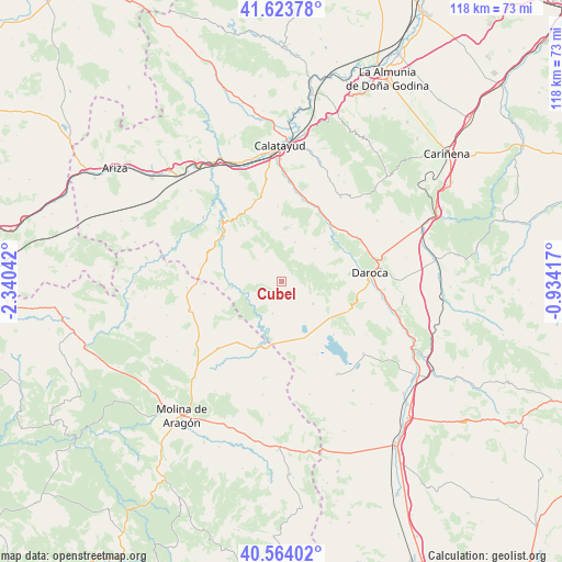
Cubel GPS coordinates[2]
41° 5' 45.744" North, 1° 38' 14.244" West
| Map corner | latitude | longitude |
|---|---|---|
| Upper-left | 41.62378°, | -2.34042° |
| Center: | 41.09604°, | -1.63729° |
| Lower-right: | 40.56402°, | -0.93417° |
| Map W x H: | 117.8×117.8 km | = 73.2×73.2mi |
| max Lat: | 43.74134° ⇑49.1% North |
| Cubel: | 41.09604° |
| min Lat: | ⇓50.9% South 27.64134° |
| min Long | Cubel | max Long |
| -18.00367° | -1.63729° | 4.2899° |
| W 71.6%⇐ | ⇒28.4% E |
Elevation
Elevation of Cubel is 1113 m = 3652 ft, and this is 515 m = 1690 ft above average elevation for this country.
| Max E: |
1682 m = 5518 ft | 6.2% |
| Cubel | 1113 m 3652 ft | |
| Avg. | 598 m = 1962 ft | |
Min E: |
0 m = 0 ft | 93.8% |
See also: Spain elevation on elevation.city.
Geographical zone
Cubel is located in North temperate zone (between Tropic of Cancer and the Arctic Circle). Distance of this Northern Tropic circle is 1963.5 km =1220.1 mi to South.| Distance of | km | miles | from Cubel |
|---|---|---|---|
| North Pole | 5437.6 | 3378.8 | to North |
| Arctic Circle | 2831.7 | 1759.5 | to North |
| Tropic Cancer | 1963.5 | 1220.1 | to South |
| Equator | 4569.5 | 2839.4 | to South |


Nearby cities:
15 places around Cubel: (largest is in red/bold)
• Abanto
6.9 km =4.3 mi,  312°
312°
• Acered
8.8 km =5.5 mi,  18°
18°
• Alarba
12.3 km =7.6 mi,  9°
9°
• Aldehuela de Liestos
6.4 km =4 mi,  236°
236°
• Atea
9.9 km =6.2 mi,  43°
43°
• Balconchán
14.9 km =9.3 mi,  93°
93°
• Castejón de Alarba
9.7 km =6 mi,  0°
0°
• Cimballa
11.4 km =7.1 mi,  272°
272°
• Embid
15.1 km =9.4 mi,  204°
204°
• Monterde
12 km =7.5 mi,  316°
316°
• Murero
14.8 km =9.2 mi,  61°
61°
• Orcajo
12.5 km =7.8 mi,  82°
82°
• Santed
12.8 km =8 mi,  123°
123°
• Torralba de los Frailes
6.9 km =4.3 mi, 196°
• Used
7.9 km =4.9 mi, 124°
Sources, notices
• [Note1] Compared only with cities in Spain existing in our database
• [Src1] Map data: © OpenStreetMap contributors (CC-BY-SA)
• [Src2] Other city data from geonames.org with taken over terms of usage.
• [Src3] Geographical zone / Annual Mean Temperature by Robert A. Rohde @ Wikipedia
