Acered geodata
Acered (Aragon) is a seat of a third-order administrative division; located in Spain in Europe/Madrid (GMT+2) time zone. In our database, there are 6762 cities with bigger population. Compared to other cities in Spain, 52.5% of cities are located further ↓South; 72% of cities are located further ←West and 68.1% of cities have lower elevation than Acered. Note1


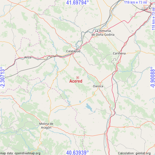
Acered GPS coordinates[2]
41° 10' 14.88" North, 1° 36' 14.4" West
| Map corner | latitude | longitude |
|---|---|---|
| Upper-left | 41.69794°, | -2.30713° |
| Center: | 41.1708°, | -1.604° |
| Lower-right: | 40.63939°, | -0.90088° |
| Map W x H: | 117.7×117.7 km | = 73.1×73.1mi |
| max Lat: | 43.74134° ⇑47.5% North |
| Acered: | 41.1708° |
| min Lat: | ⇓52.5% South 27.64134° |
| min Long | Acered | max Long |
| -18.00367° | -1.604° | 4.2899° |
| W 72%⇐ | ⇒28% E |
Elevation
Elevation of Acered is 800 m = 2625 ft, and this is 202 m = 663 ft above average elevation for this country.
| Max E: |
1682 m = 5518 ft | 31.9% |
| Acered | 800 m 2625 ft | |
| Avg. | 598 m = 1962 ft | |
Min E: |
0 m = 0 ft | 68.1% |
See also: Spain elevation on elevation.city.
Geographical zone
Acered is located in North temperate zone (between Tropic of Cancer and the Arctic Circle). Distance of this Northern Tropic circle is 1971.8 km =1225.2 mi to South.| Distance of | km | miles | from Acered |
|---|---|---|---|
| North Pole | 5429.3 | 3373.6 | to North |
| Arctic Circle | 2823.4 | 1754.4 | to North |
| Tropic Cancer | 1971.8 | 1225.2 | to South |
| Equator | 4577.8 | 2844.5 | to South |


Nearby cities:
15 places around Acered: (largest is in red/bold)
• Abanto
8.7 km =5.4 mi,  244°
244°
• Alarba
3.9 km =2.4 mi,  348°
348°
• Atea
4.2 km =2.6 mi,  105°
105°
• Castejón de Alarba
3 km =1.9 mi,  297°
297°
• Cubel
8.8 km =5.5 mi,  198°
198°
• Fuentes de Jiloca
8.6 km =5.3 mi,  41°
41°
• Manchones
11.7 km =7.3 mi,  101°
101°
• Monterde
11 km =6.8 mi,  272°
272°
• Montón
8.4 km =5.2 mi,  61°
61°
• Morata de Jiloca
8.7 km =5.4 mi,  9°
9°
• Murero
10.2 km =6.3 mi, 96°
• Olvés
8.4 km =5.2 mi,  335°
335°
• Orcajo
11.8 km =7.3 mi,  125°
125°
• Velilla de Jiloca
11.6 km =7.2 mi,  0°
0°
• Villafeliche
8.3 km =5.2 mi,  71°
71°
Sources, notices
• [Note1] Compared only with cities in Spain existing in our database
• [Src1] Map data: © OpenStreetMap contributors (CC-BY-SA)
• [Src2] Other city data from geonames.org with taken over terms of usage.
• [Src3] Geographical zone / Annual Mean Temperature by Robert A. Rohde @ Wikipedia
