Munébrega geodata
Munébrega (Aragon) is a seat of a third-order administrative division; located in Spain in Europe/Madrid (GMT+2) time zone. With population of 436 people, there are 4037 cities with bigger population in this country. Compared to other cities in Spain, 54.4% of cities are located further ↓South; 70.5% of cities are located further ←West and 60.7% of cities have lower elevation than Munébrega. Note1


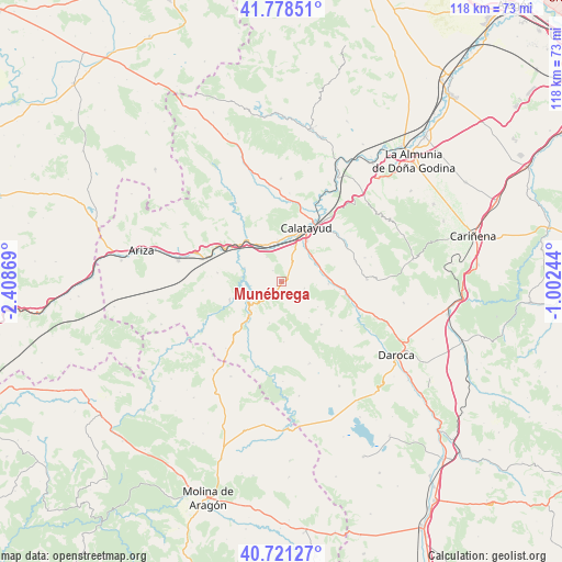
Munébrega GPS coordinates[2]
41° 15' 7.308" North, 1° 42' 20.052" West
| Map corner | latitude | longitude |
|---|---|---|
| Upper-left | 41.77851°, | -2.40869° |
| Center: | 41.25203°, | -1.70557° |
| Lower-right: | 40.72127°, | -1.00244° |
| Map W x H: | 117.6×117.6 km | = 73.1×73.1mi |
| max Lat: | 43.74134° ⇑45.6% North |
| Munébrega: | 41.25203° |
| min Lat: | ⇓54.4% South 27.64134° |
| min Long | Munébrega | max Long |
| -18.00367° | -1.70557° | 4.2899° |
| W 70.5%⇐ | ⇒29.5% E |
Elevation
Elevation of Munébrega is 749 m = 2457 ft, and this is 151 m = 495 ft above average elevation for this country.
| Max E: |
1682 m = 5518 ft | 39.3% |
| Munébrega | 749 m 2457 ft | |
| Avg. | 598 m = 1962 ft | |
Min E: |
0 m = 0 ft | 60.7% |
See also: Spain elevation on elevation.city.
Geographical zone
Munébrega is located in North temperate zone (between Tropic of Cancer and the Arctic Circle). Distance of this Northern Tropic circle is 1980.9 km =1230.9 mi to South.| Distance of | km | miles | from Munébrega |
|---|---|---|---|
| North Pole | 5420.3 | 3368 | to North |
| Arctic Circle | 2814.4 | 1748.8 | to North |
| Tropic Cancer | 1980.9 | 1230.9 | to South |
| Equator | 4586.8 | 2850.1 | to South |


Nearby cities:
15 places around Munébrega: (largest is in red/bold)
• Alarba
9.3 km =5.8 mi,  124°
124°
• Ateca
11.4 km =7.1 mi,  320°
320°
• Carenas
8.2 km =5.1 mi,  290°
290°
• Castejón de Alarba
9.6 km =6 mi,  142°
142°
• Castejón de las Armas
10.9 km =6.8 mi,  306°
306°
• Ibdes
11.4 km =7.1 mi,  249°
249°
• Maluenda
8.5 km =5.3 mi,  62°
62°
• Monterde
9 km =5.6 mi,  195°
195°
• Morata de Jiloca
10 km =6.2 mi,  92°
92°
• Nuévalos
8.3 km =5.2 mi,  237°
237°
• Olvés
5.1 km =3.2 mi,  105°
105°
• Paracuellos de Jiloca
8.8 km =5.5 mi,  38°
38°
• Terrer
8.5 km =5.3 mi,  355°
355°
• Valtorres
6 km =3.7 mi,  330°
330°
• Velilla de Jiloca
8.9 km =5.5 mi,  73°
73°
Sources, notices
• [Note1] Compared only with cities in Spain existing in our database
• [Src1] Map data: © OpenStreetMap contributors (CC-BY-SA)
• [Src2] Other city data from geonames.org with taken over terms of usage.
• [Src3] Geographical zone / Annual Mean Temperature by Robert A. Rohde @ Wikipedia
