San Miguel de Aguayo geodata
San Miguel de Aguayo (Cantabria) is a seat of a third-order administrative division; located in Spain in Europe/Madrid (GMT+2) time zone. With population of 148 people, there are 5444 cities with bigger population in this country. Compared to other cities in Spain, 94.9% of cities are located further ↓South; 60.1% of cities are located further →East and 73.2% of cities have lower elevation than San Miguel de Aguayo. Note1
Administrative division(s):
- Level 1: Cantabria
- Level 2: Provincia de Cantabria
- Level 3: San Miguel de Aguayo


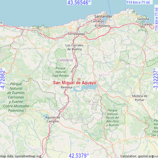
San Miguel de Aguayo GPS coordinates[2]
43° 3' 13.788" North, 4° 1' 31.8" West
| Map corner | latitude | longitude |
|---|---|---|
| Upper-left | 43.56546°, | -4.72862° |
| Center: | 43.05383°, | -4.0255° |
| Lower-right: | 42.5379°, | -3.32237° |
| Map W x H: | 114.3×114.3 km | = 71×71mi |
| max Lat: | 43.74134° ⇑5.1% North |
| San Miguel de Aguayo: | 43.05383° |
| min Lat: | ⇓94.9% South 27.64134° |
| min Long | San Miguel de A | max Long |
| -18.00367° | -4.0255° | 4.2899° |
| W 39.9%⇐ | ⇒60.1% E |
Elevation
Elevation of San Miguel de Aguayo is 837 m = 2746 ft, and this is 239 m = 784 ft above average elevation for this country.
| Max E: |
1682 m = 5518 ft | 26.8% |
| San Miguel de Aguayo | 837 m 2746 ft | |
| Avg. | 598 m = 1962 ft | |
Min E: |
0 m = 0 ft | 73.2% |
See also: Spain elevation on elevation.city.
Geographical zone
San Miguel de Aguayo is located in North temperate zone (between Tropic of Cancer and the Arctic Circle). Distance of this Northern Tropic circle is 2181.2 km =1355.3 mi to South.| Distance of | km | miles | from San Miguel de Aguayo |
|---|---|---|---|
| North Pole | 5219.9 | 3243.5 | to North |
| Arctic Circle | 2614 | 1624.3 | to North |
| Tropic Cancer | 2181.2 | 1355.3 | to South |
| Equator | 4787.1 | 2974.6 | to South |


Nearby cities:
15 places around San Miguel de Aguayo: (largest is in red/bold)
• Arenas de Iguña
14.5 km =9 mi,  352°
352°
• Arija
9.4 km =5.8 mi,  135°
135°
• Bárcena de Pie de Concha
8.4 km =5.2 mi,  342°
342°
• Los Corrales de Buelna
23.6 km =14.7 mi, 350°
• Mataporquera
22.8 km =14.2 mi,  209°
209°
• Molledo
10.8 km =6.7 mi, 352°
• Pesquera
5.4 km =3.4 mi,  305°
305°
• Reinosa
11 km =6.8 mi,  236°
236°
• San Pedro del Romeral
18.1 km =11.2 mi,  67°
67°
• Santiurde de Reinosa
4.8 km =3 mi,  280°
280°
• Santiurde de Toranzo
21.7 km =13.5 mi,  18°
18°
• Selaya
25.2 km =15.7 mi,  45°
45°
• Vega de Pas
22.8 km =14.2 mi,  59°
59°
• Villaescusa
15.3 km =9.5 mi,  228°
228°
• Villafufre
25.9 km =16.1 mi, 24°
Sources, notices
• [Note1] Compared only with cities in Spain existing in our database
• [Src1] Map data: © OpenStreetMap contributors (CC-BY-SA)
• [Src2] Other city data from geonames.org with taken over terms of usage.
• [Src3] Geographical zone / Annual Mean Temperature by Robert A. Rohde @ Wikipedia
