Toreno geodata
Toreno (Castille and León) is a seat of a third-order administrative division; located in Spain in Europe/Madrid (GMT+2) time zone. With population of 3,661 people, there are 1546 cities with bigger population in this country. Compared to other cities in Spain, 91.5% of cities are located further ↓South; 91.3% of cities are located further →East and 52.4% of cities have lower elevation than Toreno. Note1


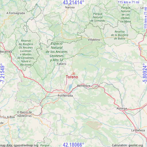
Toreno GPS coordinates[2]
42° 41' 58.38" North, 6° 30' 44.496" West
| Map corner | latitude | longitude |
|---|---|---|
| Upper-left | 43.21414°, | -7.21549° |
| Center: | 42.69955°, | -6.51236° |
| Lower-right: | 42.18066°, | -5.80924° |
| Map W x H: | 114.9×114.9 km | = 71.4×71.4mi |
| max Lat: | 43.74134° ⇑8.5% North |
| Toreno: | 42.69955° |
| min Lat: | ⇓91.5% South 27.64134° |
| min Long | Toreno | max Long |
| -18.00367° | -6.51236° | 4.2899° |
| W 8.7%⇐ | ⇒91.3% E |
Elevation
Elevation of Toreno is 683 m = 2241 ft, and this is 85 m = 279 ft above average elevation for this country.
| Max E: |
1682 m = 5518 ft | 47.6% |
| Toreno | 683 m 2241 ft | |
| Avg. | 598 m = 1962 ft | |
Min E: |
0 m = 0 ft | 52.4% |
See also: Spain elevation on elevation.city.
Geographical zone
Toreno is located in North temperate zone (between Tropic of Cancer and the Arctic Circle). Distance of this Northern Tropic circle is 2141.8 km =1330.9 mi to South.| Distance of | km | miles | from Toreno |
|---|---|---|---|
| North Pole | 5259.3 | 3268 | to North |
| Arctic Circle | 2653.4 | 1648.7 | to North |
| Tropic Cancer | 2141.8 | 1330.9 | to South |
| Equator | 4747.7 | 2950.1 | to South |


Nearby cities:
15 places around Toreno: (largest is in red/bold)
• Arganza
15.6 km =9.7 mi,  245°
245°
• Bembibre
12.1 km =7.5 mi,  138°
138°
• Berlanga del Bierzo
8.4 km =5.2 mi,  294°
294°
• Camponaraya
18.5 km =11.5 mi,  223°
223°
• Castropodame
13.8 km =8.6 mi,  164°
164°
• Congosto
9.1 km =5.7 mi,  184°
184°
• Cubillos del Sil
9.3 km =5.8 mi,  206°
206°
• Fabero
12 km =7.5 mi,  309°
309°
• Folgoso de la Ribera
16.8 km =10.4 mi,  110°
110°
• Molinaseca
17.9 km =11.1 mi, 181°
• Ponferrada
18.3 km =11.4 mi,  201°
201°
• Páramo del Sil
13.6 km =8.5 mi,  8°
8°
• Sancedo
10.6 km =6.6 mi, 249°
• Torre del Bierzo
15.7 km =9.8 mi,  130°
130°
• Vega de Espinareda
12 km =7.5 mi,  283°
283°
Sources, notices
• [Note1] Compared only with cities in Spain existing in our database
• [Src1] Map data: © OpenStreetMap contributors (CC-BY-SA)
• [Src2] Other city data from geonames.org with taken over terms of usage.
• [Src3] Geographical zone / Annual Mean Temperature by Robert A. Rohde @ Wikipedia
