Alcañiz geodata
Alcañiz (Aragon) is a seat of a third-order administrative division; located in Spain in Europe/Madrid (GMT+2) time zone. With population of 16,392 people, there are 574 cities with bigger population in this country. Compared to other cities in Spain, 50.4% of cities are located further ↑North; 86.1% of cities are located further ←West and 72.1% of cities have higher elevation than Alcañiz. Note1


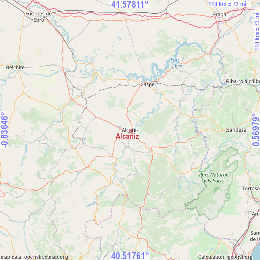
Alcañiz GPS coordinates[2]
41° 3' 0" North, 0° 7' 59.988" West
| Map corner | latitude | longitude |
|---|---|---|
| Upper-left | 41.57811°, | -0.83646° |
| Center: | 41.05°, | -0.13333° |
| Lower-right: | 40.51761°, | 0.56979° |
| Map W x H: | 117.9×117.9 km | = 73.3×73.3mi |
| max Lat: | 43.74134° ⇑50.4% North |
| Alcañiz: | 41.05° |
| min Lat: | ⇓49.6% South 27.64134° |
| min Long | Alcañiz | max Long |
| -18.00367° | -0.13333° | 4.2899° |
| W 86.1%⇐ | ⇒13.9% E |
Elevation
Elevation of Alcañiz is 346 m = 1135 ft, and this is 252 m = 827 ft below average elevation for this country.
| Max E: |
1682 m = 5518 ft | 72.1% |
| Avg. | 598 m = 1962 ft | |
| Alcañiz | 346 m = 1135 ft | |
Min E: |
0 m = 0 ft | 27.9% |
See also: Spain elevation on elevation.city.
Geographical zone
Alcañiz is located in North temperate zone (between Tropic of Cancer and the Arctic Circle). Distance of this Northern Tropic circle is 1958.4 km =1216.9 mi to South.| Distance of | km | miles | from Alcañiz |
|---|---|---|---|
| North Pole | 5442.7 | 3381.9 | to North |
| Arctic Circle | 2836.8 | 1762.7 | to North |
| Tropic Cancer | 1958.4 | 1216.9 | to South |
| Equator | 4564.3 | 2836.1 | to South |


Nearby cities:
15 places around Alcañiz: (largest is in red/bold)
• Calanda
14.7 km =9.1 mi,  214°
214°
• Caspe
21.9 km =13.6 mi,  21°
21°
• Castelserás
7.7 km =4.8 mi,  188°
188°
• Chiprana
23.7 km =14.7 mi,  1°
1°
• Foz-Calanda
18 km =11.2 mi,  217°
217°
• Fórnoles
20.5 km =12.7 mi,  147°
147°
• La Ginebrosa
20 km =12.4 mi,  180°
180°
• Maella
24.2 km =15 mi,  70°
70°
• Mazaleón
19.8 km =12.3 mi,  89°
89°
• Torre del Compte
24 km =14.9 mi,  121°
121°
• Torrecilla de Alcañiz
10.6 km =6.6 mi,  160°
160°
• Torrevelilla
16.6 km =10.3 mi,  173°
173°
• Valdealgorfa
10.6 km =6.6 mi,  128°
128°
• Valdeltormo
19.5 km =12.1 mi,  111°
111°
• Valjunquera
17.2 km =10.7 mi, 129°
Sources, notices
• [Note1] Compared only with cities in Spain existing in our database
• [Src1] Map data: © OpenStreetMap contributors (CC-BY-SA)
• [Src2] Other city data from geonames.org with taken over terms of usage.
• [Src3] Geographical zone / Annual Mean Temperature by Robert A. Rohde @ Wikipedia
