Páramo del Sil geodata
Páramo del Sil (Castille and León) is a seat of a third-order administrative division; located in Spain in Europe/Madrid (GMT+2) time zone. With population of 754 people, there are 3297 cities with bigger population in this country. Compared to other cities in Spain, 92.9% of cities are located further ↓South; 91.1% of cities are located further →East and 78.1% of cities have lower elevation than Páramo del Sil. Note1
Administrative division(s):
- Level 1: Castille and León
- Level 2: Provincia de León
- Level 3: Páramo del Sil


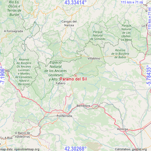
Páramo del Sil GPS coordinates[2]
42° 49' 14.016" North, 6° 29' 14.892" West
| Map corner | latitude | longitude |
|---|---|---|
| Upper-left | 43.33414°, | -7.1906° |
| Center: | 42.82056°, | -6.48747° |
| Lower-right: | 42.30268°, | -5.78435° |
| Map W x H: | 114.7×114.7 km | = 71.3×71.3mi |
| max Lat: | 43.74134° ⇑7.1% North |
| Páramo del Sil: | 42.82056° |
| min Lat: | ⇓92.9% South 27.64134° |
| min Long | Páramo del Sil | max Long |
| -18.00367° | -6.48747° | 4.2899° |
| W 8.9%⇐ | ⇒91.1% E |
Elevation
Elevation of Páramo del Sil is 880 m = 2887 ft, and this is 282 m = 925 ft above average elevation for this country.
| Max E: |
1682 m = 5518 ft | 21.9% |
| Páramo del Sil | 880 m 2887 ft | |
| Avg. | 598 m = 1962 ft | |
Min E: |
0 m = 0 ft | 78.1% |
See also: Spain elevation on elevation.city.
Geographical zone
Páramo del Sil is located in North temperate zone (between Tropic of Cancer and the Arctic Circle). Distance of this Northern Tropic circle is 2155.3 km =1339.2 mi to South.| Distance of | km | miles | from Páramo del Sil |
|---|---|---|---|
| North Pole | 5245.9 | 3259.7 | to North |
| Arctic Circle | 2640 | 1640.4 | to North |
| Tropic Cancer | 2155.3 | 1339.2 | to South |
| Equator | 4761.2 | 2958.5 | to South |


Nearby cities:
15 places around Páramo del Sil: (largest is in red/bold)
• Bembibre
23.3 km =14.5 mi,  165°
165°
• Berlanga del Bierzo
13.9 km =8.6 mi,  224°
224°
• Candín
19.7 km =12.2 mi,  268°
268°
• Cerredo
14 km =8.7 mi,  359°
359°
• Congosto
22.7 km =14.1 mi,  186°
186°
• Cubillos del Sil
22.6 km =14 mi,  195°
195°
• Degaña
14.8 km =9.2 mi,  333°
333°
• Fabero
12.8 km =8 mi,  242°
242°
• Igüeña
20 km =12.4 mi,  120°
120°
• Palacios del Sil
7.7 km =4.8 mi,  36°
36°
• Peranzanes
13.5 km =8.4 mi,  297°
297°
• Sancedo
20.9 km =13 mi, 215°
• Toreno
13.6 km =8.5 mi, 188°
• Vega de Espinareda
17.3 km =10.7 mi,  232°
232°
• Villablino
19 km =11.8 mi,  46°
46°
Sources, notices
• [Note1] Compared only with cities in Spain existing in our database
• [Src1] Map data: © OpenStreetMap contributors (CC-BY-SA)
• [Src2] Other city data from geonames.org with taken over terms of usage.
• [Src3] Geographical zone / Annual Mean Temperature by Robert A. Rohde @ Wikipedia
