Hoyos geodata
Hoyos (Extremadura) is a seat of a third-order administrative division; located in Spain in Europe/Madrid (GMT+2) time zone. With population of 963 people, there are 2999 cities with bigger population in this country. Compared to other cities in Spain, 67.6% of cities are located further ↑North; 93% of cities are located further →East and 60.6% of cities have higher elevation than Hoyos. Note1


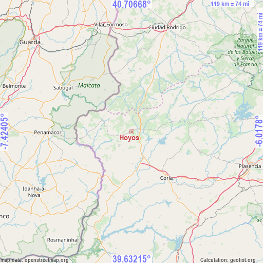
Hoyos GPS coordinates[2]
40° 10' 17.544" North, 6° 43' 15.312" West
| Map corner | latitude | longitude |
|---|---|---|
| Upper-left | 40.70668°, | -7.42405° |
| Center: | 40.17154°, | -6.72092° |
| Lower-right: | 39.63215°, | -6.0178° |
| Map W x H: | 119.5×119.5 km | = 74.3×74.3mi |
| max Lat: | 43.74134° ⇑67.6% North |
| Hoyos: | 40.17154° |
| min Lat: | ⇓32.4% South 27.64134° |
| min Long | Hoyos | max Long |
| -18.00367° | -6.72092° | 4.2899° |
| W 7%⇐ | ⇒93% E |
Elevation
Elevation of Hoyos is 519 m = 1703 ft, and this is 79 m = 259 ft below average elevation for this country.
| Max E: |
1682 m = 5518 ft | 60.6% |
| Avg. | 598 m = 1962 ft | |
| Hoyos | 519 m = 1703 ft | |
Min E: |
0 m = 0 ft | 39.4% |
See also: Spain elevation on elevation.city.
Geographical zone
Hoyos is located in North temperate zone (between Tropic of Cancer and the Arctic Circle). Distance of this Northern Tropic circle is 1860.7 km =1156.2 mi to South.| Distance of | km | miles | from Hoyos |
|---|---|---|---|
| North Pole | 5540.4 | 3442.6 | to North |
| Arctic Circle | 2934.5 | 1823.4 | to North |
| Tropic Cancer | 1860.7 | 1156.2 | to South |
| Equator | 4466.7 | 2775.5 | to South |


Nearby cities:
15 places around Hoyos: (largest is in red/bold)
• Acebo
3.3 km =2.1 mi,  5°
5°
• Cadalso
17 km =10.6 mi,  64°
64°
• Cilleros
8.8 km =5.5 mi,  224°
224°
• Eljas
11.8 km =7.3 mi,  295°
295°
• Gata
12.8 km =8 mi, 55°
• Huélaga
15.7 km =9.8 mi,  145°
145°
• Moraleja
12.7 km =7.9 mi,  155°
155°
• Navasfrías
16.3 km =10.1 mi,  328°
328°
• Perales del Puerto
3.7 km =2.3 mi,  117°
117°
• San Martín de Trevejo
7.8 km =4.8 mi,  305°
305°
• Santibáñez el Alto
14.8 km =9.2 mi,  84°
84°
• Torre de Don Miguel
13.5 km =8.4 mi, 64°
• Valverde del Fresno
14.5 km =9 mi,  292°
292°
• Villamiel
5.6 km =3.5 mi, 287°
• Villasbuenas de Gata
8.1 km =5 mi, 84°
Sources, notices
• [Note1] Compared only with cities in Spain existing in our database
• [Src1] Map data: © OpenStreetMap contributors (CC-BY-SA)
• [Src2] Other city data from geonames.org with taken over terms of usage.
• [Src3] Geographical zone / Annual Mean Temperature by Robert A. Rohde @ Wikipedia
