Cachorrilla geodata
Cachorrilla (Extremadura) is a seat of a third-order administrative division; located in Spain in Europe/Madrid (GMT+2) time zone. With population of 87 people, there are 6070 cities with bigger population in this country. Compared to other cities in Spain, 71.4% of cities are located further ↑North; 92.6% of cities are located further →East and 73.7% of cities have higher elevation than Cachorrilla. Note1


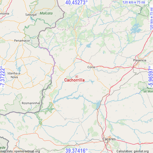
Cachorrilla GPS coordinates[2]
39° 54' 56.052" North, 6° 40' 8.724" West
| Map corner | latitude | longitude |
|---|---|---|
| Upper-left | 40.45273°, | -7.37222° |
| Center: | 39.91557°, | -6.66909° |
| Lower-right: | 39.37416°, | -5.96597° |
| Map W x H: | 119.9×119.9 km | = 74.5×74.5mi |
| max Lat: | 43.74134° ⇑71.4% North |
| Cachorrilla: | 39.91557° |
| min Lat: | ⇓28.6% South 27.64134° |
| min Long | Cachorrilla | max Long |
| -18.00367° | -6.66909° | 4.2899° |
| W 7.4%⇐ | ⇒92.6% E |
Elevation
Elevation of Cachorrilla is 319 m = 1047 ft, and this is 279 m = 915 ft below average elevation for this country.
| Max E: |
1682 m = 5518 ft | 73.7% |
| Avg. | 598 m = 1962 ft | |
| Cachorrilla | 319 m = 1047 ft | |
Min E: |
0 m = 0 ft | 26.3% |
See also: Spain elevation on elevation.city.
Geographical zone
Cachorrilla is located in North temperate zone (between Tropic of Cancer and the Arctic Circle). Distance of this Northern Tropic circle is 1832.3 km =1138.5 mi to South.| Distance of | km | miles | from Cachorrilla |
|---|---|---|---|
| North Pole | 5568.9 | 3460.4 | to North |
| Arctic Circle | 2963 | 1841.1 | to North |
| Tropic Cancer | 1832.3 | 1138.5 | to South |
| Equator | 4438.2 | 2757.8 | to South |


Nearby cities:
15 places around Cachorrilla: (largest is in red/bold)
• Acehuche
12.9 km =8 mi,  166°
166°
• Calzadilla
19.8 km =12.3 mi,  35°
35°
• Casas de Don Gómez
11.9 km =7.4 mi,  29°
29°
• Casillas de Coria
6.2 km =3.9 mi, 26°
• Ceclavín
13.7 km =8.5 mi,  220°
220°
• Cilleros
24.5 km =15.2 mi,  334°
334°
• Coria
13.7 km =8.5 mi,  56°
56°
• Huélaga
16.2 km =10.1 mi,  16°
16°
• Moraleja
16.8 km =10.4 mi,  2°
2°
• Pedroso de Acim
24.1 km =15 mi,  114°
114°
• Pescueza
2 km =1.2 mi,  82°
82°
• Portaje
9.1 km =5.7 mi,  88°
88°
• Portezuelo
20.2 km =12.6 mi,  124°
124°
• Torrejoncillo
17.4 km =10.8 mi,  96°
96°
• Zarza la Mayor
17 km =10.6 mi,  255°
255°
Sources, notices
• [Note1] Compared only with cities in Spain existing in our database
• [Src1] Map data: © OpenStreetMap contributors (CC-BY-SA)
• [Src2] Other city data from geonames.org with taken over terms of usage.
• [Src3] Geographical zone / Annual Mean Temperature by Robert A. Rohde @ Wikipedia
