Villamiel geodata
Villamiel (Extremadura) is a seat of a third-order administrative division; located in Spain in Europe/Madrid (GMT+2) time zone. With population of 611 people, there are 3587 cities with bigger population in this country. Compared to other cities in Spain, 67.4% of cities are located further ↑North; 93.3% of cities are located further →East and 62.1% of cities have lower elevation than Villamiel. Note1


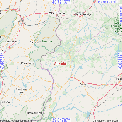
Villamiel GPS coordinates[2]
40° 11' 10.86" North, 6° 47' 3.3" West
| Map corner | latitude | longitude |
|---|---|---|
| Upper-left | 40.72137°, | -7.48737° |
| Center: | 40.18635°, | -6.78425° |
| Lower-right: | 39.64707°, | -6.08112° |
| Map W x H: | 119.5×119.5 km | = 74.3×74.3mi |
| max Lat: | 43.74134° ⇑67.4% North |
| Villamiel: | 40.18635° |
| min Lat: | ⇓32.6% South 27.64134° |
| min Long | Villamiel | max Long |
| -18.00367° | -6.78425° | 4.2899° |
| W 6.7%⇐ | ⇒93.3% E |
Elevation
Elevation of Villamiel is 758 m = 2487 ft, and this is 160 m = 525 ft above average elevation for this country.
| Max E: |
1682 m = 5518 ft | 37.9% |
| Villamiel | 758 m 2487 ft | |
| Avg. | 598 m = 1962 ft | |
Min E: |
0 m = 0 ft | 62.1% |
See also: Spain elevation on elevation.city.
Geographical zone
Villamiel is located in North temperate zone (between Tropic of Cancer and the Arctic Circle). Distance of this Northern Tropic circle is 1862.4 km =1157.2 mi to South.| Distance of | km | miles | from Villamiel |
|---|---|---|---|
| North Pole | 5538.8 | 3441.6 | to North |
| Arctic Circle | 2932.9 | 1822.4 | to North |
| Tropic Cancer | 1862.4 | 1157.2 | to South |
| Equator | 4468.3 | 2776.5 | to South |


Nearby cities:
15 places around Villamiel: (largest is in red/bold)
• Acebo
6 km =3.7 mi,  74°
74°
• Cilleros
8 km =5 mi,  185°
185°
• Eljas
6.2 km =3.9 mi,  302°
302°
• Gata
16.9 km =10.5 mi, 70°
• Hoyos
5.6 km =3.5 mi,  107°
107°
• Huélaga
20.4 km =12.7 mi,  135°
135°
• Moraleja
17 km =10.6 mi, 141°
• Navasfrías
12.6 km =7.8 mi,  346°
346°
• Perales del Puerto
9.3 km =5.8 mi, 111°
• Peñaparda
17.9 km =11.1 mi,  33°
33°
• San Martín de Trevejo
3 km =1.9 mi,  341°
341°
• Santibáñez el Alto
20.1 km =12.5 mi,  90°
90°
• Torre de Don Miguel
18.1 km =11.2 mi,  76°
76°
• Valverde del Fresno
8.9 km =5.5 mi, 296°
• Villasbuenas de Gata
13.4 km =8.3 mi, 93°
Sources, notices
• [Note1] Compared only with cities in Spain existing in our database
• [Src1] Map data: © OpenStreetMap contributors (CC-BY-SA)
• [Src2] Other city data from geonames.org with taken over terms of usage.
• [Src3] Geographical zone / Annual Mean Temperature by Robert A. Rohde @ Wikipedia
