Acebo geodata
Acebo (Extremadura) is a seat of a third-order administrative division; located in Spain in Europe/Madrid (GMT+2) time zone. With population of 702 people, there are 3401 cities with bigger population in this country. Compared to other cities in Spain, 67.2% of cities are located further ↑North; 92.9% of cities are located further →East and 61.4% of cities have higher elevation than Acebo. Note1


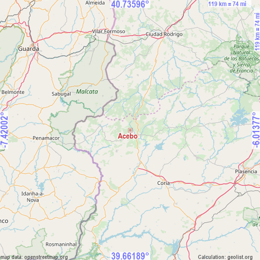
Acebo GPS coordinates[2]
40° 12' 3.78" North, 6° 43' 0.804" West
| Map corner | latitude | longitude |
|---|---|---|
| Upper-left | 40.73596°, | -7.42002° |
| Center: | 40.20105°, | -6.71689° |
| Lower-right: | 39.66189°, | -6.01377° |
| Map W x H: | 119.4×119.4 km | = 74.2×74.2mi |
| max Lat: | 43.74134° ⇑67.2% North |
| Acebo: | 40.20105° |
| min Lat: | ⇓32.8% South 27.64134° |
| min Long | Acebo | max Long |
| -18.00367° | -6.71689° | 4.2899° |
| W 7.1%⇐ | ⇒92.9% E |
Elevation
Elevation of Acebo is 506 m = 1660 ft, and this is 92 m = 302 ft below average elevation for this country.
| Max E: |
1682 m = 5518 ft | 61.4% |
| Avg. | 598 m = 1962 ft | |
| Acebo | 506 m = 1660 ft | |
Min E: |
0 m = 0 ft | 38.6% |
See also: Spain elevation on elevation.city.
Geographical zone
Acebo is located in North temperate zone (between Tropic of Cancer and the Arctic Circle). Distance of this Northern Tropic circle is 1864 km =1158.2 mi to South.| Distance of | km | miles | from Acebo |
|---|---|---|---|
| North Pole | 5537.1 | 3440.6 | to North |
| Arctic Circle | 2931.2 | 1821.4 | to North |
| Tropic Cancer | 1864 | 1158.2 | to South |
| Equator | 4469.9 | 2777.5 | to South |


Nearby cities:
15 places around Acebo: (largest is in red/bold)
• Cadalso
15.5 km =9.6 mi,  74°
74°
• Cilleros
11.5 km =7.1 mi,  213°
213°
• Eljas
11.1 km =6.9 mi,  278°
278°
• Gata
11 km =6.8 mi, 68°
• Hoyos
3.3 km =2.1 mi,  185°
185°
• Moraleja
15.7 km =9.8 mi,  161°
161°
• Navasfrías
13.8 km =8.6 mi,  320°
320°
• Perales del Puerto
5.8 km =3.6 mi,  149°
149°
• Peñaparda
13.9 km =8.6 mi,  16°
16°
• San Martín de Trevejo
6.8 km =4.2 mi, 280°
• Santibáñez el Alto
14.5 km =9 mi,  96°
96°
• Torre de Don Miguel
12.1 km =7.5 mi,  78°
78°
• Valverde del Fresno
13.9 km =8.6 mi, 279°
• Villamiel
6 km =3.7 mi,  254°
254°
• Villasbuenas de Gata
8.1 km =5 mi,  107°
107°
Sources, notices
• [Note1] Compared only with cities in Spain existing in our database
• [Src1] Map data: © OpenStreetMap contributors (CC-BY-SA)
• [Src2] Other city data from geonames.org with taken over terms of usage.
• [Src3] Geographical zone / Annual Mean Temperature by Robert A. Rohde @ Wikipedia
