Sartajada geodata
Sartajada (Castille-La Mancha) is a seat of a third-order administrative division; located in Spain in Europe/Madrid (GMT+2) time zone. With population of 134 people, there are 5549 cities with bigger population in this country. Compared to other cities in Spain, 67% of cities are located further ↑North; 69.7% of cities are located further →East and 65.2% of cities have higher elevation than Sartajada. Note1
Administrative division(s):
- Level 1: Castille-La Mancha
- Level 2: Province of Toledo
- Level 3: Sartajada


Sartajada GPS coordinates[2]
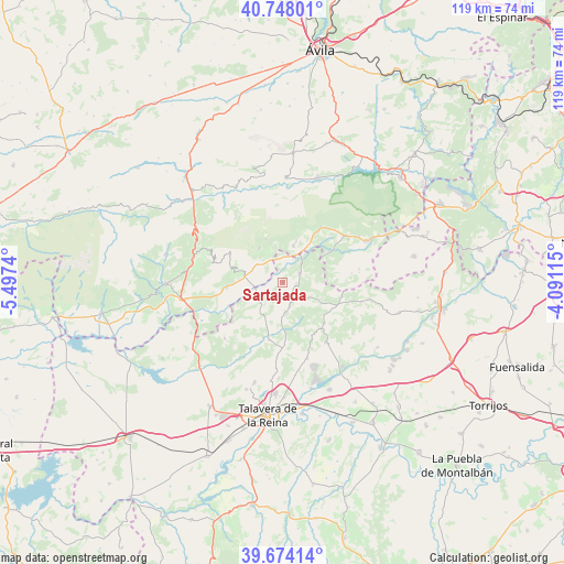
40° 12' 47.52" North, 4° 47' 39.372" West
| Map corner | latitude | longitude |
|---|---|---|
| Upper-left | 40.74801°, | -5.4974° |
| Center: | 40.2132°, | -4.79427° |
| Lower-right: | 39.67414°, | -4.09115° |
| Map W x H: | 119.4×119.4 km | = 74.2×74.2mi |
| max Lat: | 43.74134° ⇑67% North |
| Sartajada: | 40.2132° |
| min Lat: | ⇓33% South 27.64134° |
| min Long | Sartajada | max Long |
| -18.00367° | -4.79427° | 4.2899° |
| W 30.3%⇐ | ⇒69.7% E |
Elevation
Elevation of Sartajada is 457 m = 1499 ft, and this is 141 m = 463 ft below average elevation for this country.
| Max E: |
1682 m = 5518 ft | 65.2% |
| Avg. | 598 m = 1962 ft | |
| Sartajada | 457 m = 1499 ft | |
Min E: |
0 m = 0 ft | 34.8% |
See also: Spain elevation on elevation.city.
Geographical zone
Sartajada is located in North temperate zone (between Tropic of Cancer and the Arctic Circle). Distance of this Northern Tropic circle is 1865.4 km =1159.1 mi to South.| Distance of | km | miles | from Sartajada |
|---|---|---|---|
| North Pole | 5535.8 | 3439.8 | to North |
| Arctic Circle | 2929.9 | 1820.6 | to North |
| Tropic Cancer | 1865.4 | 1159.1 | to South |
| Equator | 4471.3 | 2778.3 | to South |


Nearby cities:
15 places around Sartajada: (largest is in red/bold)
• Almendral de la Cañada
5.5 km =3.4 mi,  125°
125°
• Buenaventura
6.2 km =3.9 mi,  229°
229°
• Casavieja
8.1 km =5 mi,  16°
16°
• Castillo de Bayuela
15.6 km =9.7 mi,  143°
143°
• El Real de San Vicente
12.3 km =7.6 mi, 134°
• Fresnedilla
14.8 km =9.2 mi,  81°
81°
• Gavilanes
8.8 km =5.5 mi,  325°
325°
• Higuera de las Dueñas
16.4 km =10.2 mi, 79°
• Hinojosa de San Vicente
13.5 km =8.4 mi,  153°
153°
• Lanzahita
12 km =7.5 mi,  265°
265°
• Mijares
9.9 km =6.2 mi,  338°
338°
• Navamorcuende
6.3 km =3.9 mi,  173°
173°
• Pedro Bernardo
10.3 km =6.4 mi,  288°
288°
• Piedralaves
14 km =8.7 mi,  34°
34°
• Sotillo de las Palomas
12.5 km =7.8 mi,  192°
192°
Sources, notices
• [Note1] Compared only with cities in Spain existing in our database
• [Src1] Map data: © OpenStreetMap contributors (CC-BY-SA)
• [Src2] Other city data from geonames.org with taken over terms of usage.
• [Src3] Geographical zone / Annual Mean Temperature by Robert A. Rohde @ Wikipedia
