El Escorial geodata
El Escorial (Madrid) is a populated place; located in Spain in Europe/Madrid (GMT+2) time zone. With population of 14,979 people, there are 621 cities with bigger population in this country. Compared to other cities in Spain, 60.2% of cities are located further ↑North; 61.7% of cities are located further →East and 82% of cities have lower elevation than El Escorial. Note1


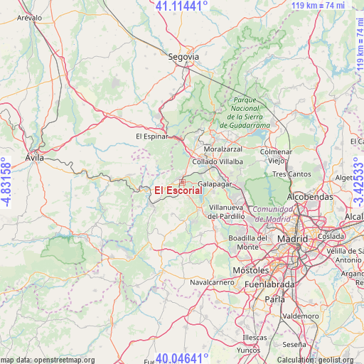
El Escorial GPS coordinates[2]
40° 34' 57.144" North, 4° 7' 42.456" West
| Map corner | latitude | longitude |
|---|---|---|
| Upper-left | 41.11441°, | -4.83158° |
| Center: | 40.58254°, | -4.12846° |
| Lower-right: | 40.04641°, | -3.42533° |
| Map W x H: | 118.8×118.7 km | = 73.8×73.8mi |
| max Lat: | 43.74134° ⇑60.2% North |
| El Escorial: | 40.58254° |
| min Lat: | ⇓39.8% South 27.64134° |
| min Long | El Escorial | max Long |
| -18.00367° | -4.12846° | 4.2899° |
| W 38.3%⇐ | ⇒61.7% E |
Elevation
Elevation of El Escorial is 917 m = 3009 ft, and this is 319 m = 1047 ft above average elevation for this country.
| Max E: |
1682 m = 5518 ft | 18% |
| El Escorial | 917 m 3009 ft | |
| Avg. | 598 m = 1962 ft | |
Min E: |
0 m = 0 ft | 82% |
See also: Spain elevation on elevation.city.
Geographical zone
El Escorial is located in North temperate zone (between Tropic of Cancer and the Arctic Circle). Distance of this Northern Tropic circle is 1906.4 km =1184.6 mi to South.| Distance of | km | miles | from El Escorial |
|---|---|---|---|
| North Pole | 5494.7 | 3414.2 | to North |
| Arctic Circle | 2888.8 | 1795 | to North |
| Tropic Cancer | 1906.4 | 1184.6 | to South |
| Equator | 4512.4 | 2803.9 | to South |


Nearby cities:
15 places around El Escorial: (largest is in red/bold)
• Alpedrete
12.2 km =7.6 mi,  45°
45°
• Collado Mediano
15.2 km =9.4 mi,  35°
35°
• Collado-Villalba
12 km =7.5 mi,  60°
60°
• Colmenarejo
9.7 km =6 mi,  104°
104°
• Fresnedillas
11.2 km =7 mi,  198°
198°
• Galapagar
10.5 km =6.5 mi,  92°
92°
• Guadarrama
10.6 km =6.6 mi,  18°
18°
• Navalagamella
12.6 km =7.8 mi,  178°
178°
• Navalquejigo
7.2 km =4.5 mi,  67°
67°
• Peguerinos
10 km =6.2 mi,  299°
299°
• Robledo de Chavela
12.9 km =8 mi,  225°
225°
• San Lorenzo de El Escorial
1.9 km =1.2 mi, 301°
• Santa María de la Alameda
11 km =6.8 mi,  277°
277°
• Valdemorillo
10.5 km =6.5 mi,  150°
150°
• Zarzalejo
5.9 km =3.7 mi, 229°
Sources, notices
• [Note1] Compared only with cities in Spain existing in our database
• [Src1] Map data: © OpenStreetMap contributors (CC-BY-SA)
• [Src2] Other city data from geonames.org with taken over terms of usage.
• [Src3] Geographical zone / Annual Mean Temperature by Robert A. Rohde @ Wikipedia
