San Adrián geodata
San Adrián (Navarre) is a seat of a third-order administrative division; located in Spain in Europe/Madrid (GMT+2) time zone. With population of 6,076 people, there are 1129 cities with bigger population in this country. Compared to other cities in Spain, 82.8% of cities are located further ↓South; 68.1% of cities are located further ←West and 74.6% of cities have higher elevation than San Adrián. Note1


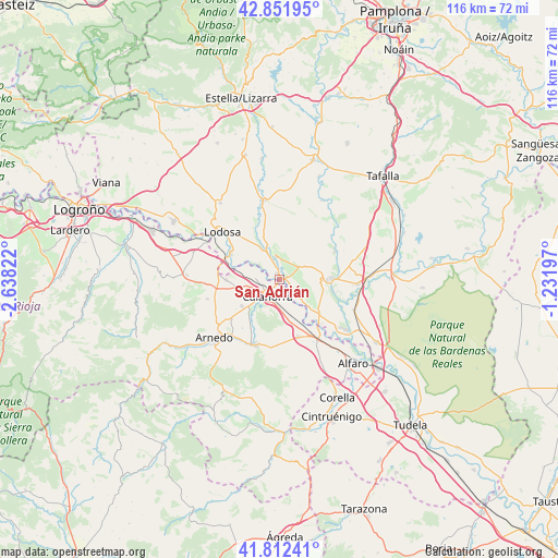
San Adrián GPS coordinates[2]
42° 20' 3.588" North, 1° 56' 6.324" West
| Map corner | latitude | longitude |
|---|---|---|
| Upper-left | 42.85195°, | -2.63822° |
| Center: | 42.33433°, | -1.93509° |
| Lower-right: | 41.81241°, | -1.23197° |
| Map W x H: | 115.6×115.6 km | = 71.8×71.8mi |
| max Lat: | 43.74134° ⇑17.2% North |
| San Adrián: | 42.33433° |
| min Lat: | ⇓82.8% South 27.64134° |
| min Long | San Adrián | max Long |
| -18.00367° | -1.93509° | 4.2899° |
| W 68.1%⇐ | ⇒31.9% E |
Elevation
Elevation of San Adrián is 301 m = 988 ft, and this is 297 m = 974 ft below average elevation for this country.
| Max E: |
1682 m = 5518 ft | 74.6% |
| Avg. | 598 m = 1962 ft | |
| San Adrián | 301 m = 988 ft | |
Min E: |
0 m = 0 ft | 25.4% |
See also: Spain elevation on elevation.city.
Geographical zone
San Adrián is located in North temperate zone (between Tropic of Cancer and the Arctic Circle). Distance of this Northern Tropic circle is 2101.2 km =1305.6 mi to South.| Distance of | km | miles | from San Adrián |
|---|---|---|---|
| North Pole | 5299.9 | 3293.2 | to North |
| Arctic Circle | 2694 | 1674 | to North |
| Tropic Cancer | 2101.2 | 1305.6 | to South |
| Equator | 4707.1 | 2924.9 | to South |


Nearby cities:
15 places around San Adrián: (largest is in red/bold)
• Aldeanueva de Ebro
12.3 km =7.6 mi,  161°
161°
• Andosilla
4.8 km =3 mi,  352°
352°
• Autol
14.3 km =8.9 mi,  203°
203°
• Azagra
4.8 km =3 mi,  142°
142°
• Calahorra
4.1 km =2.5 mi,  217°
217°
• Cárcar
7.5 km =4.7 mi,  331°
331°
• El Villar de Arnedo
13.3 km =8.3 mi,  263°
263°
• Falces
13.2 km =8.2 mi,  62°
62°
• Funes
11.3 km =7 mi,  100°
100°
• Lodosa
15.3 km =9.5 mi,  310°
310°
• Peralta
11.1 km =6.9 mi,  87°
87°
• Pradejón
11 km =6.8 mi,  270°
270°
• Quel
15.1 km =9.4 mi, 219°
• Rincón de Soto
13 km =8.1 mi,  148°
148°
• Sartaguda
11.4 km =7.1 mi,  298°
298°
Sources, notices
• [Note1] Compared only with cities in Spain existing in our database
• [Src1] Map data: © OpenStreetMap contributors (CC-BY-SA)
• [Src2] Other city data from geonames.org with taken over terms of usage.
• [Src3] Geographical zone / Annual Mean Temperature by Robert A. Rohde @ Wikipedia
