Calahorra geodata
Calahorra (La Rioja) is a seat of a third-order administrative division; located in Spain in Europe/Madrid (GMT+2) time zone. With population of 24,787 people, there are 378 cities with bigger population in this country. Compared to other cities in Spain, 81.9% of cities are located further ↓South; 67.9% of cities are located further ←West and 71.8% of cities have higher elevation than Calahorra. Note1


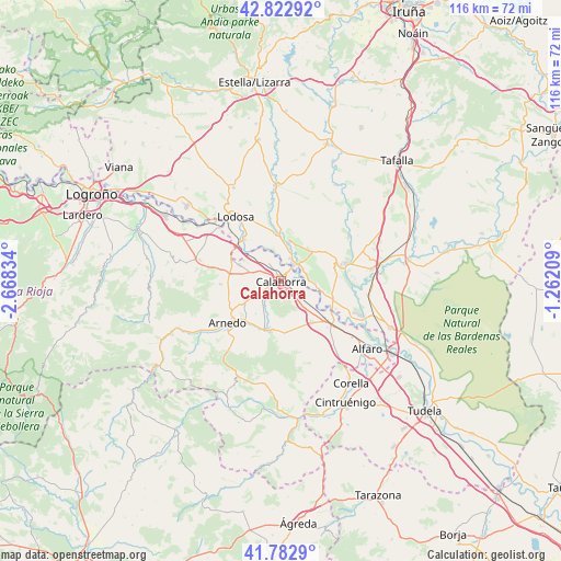
Calahorra GPS coordinates[2]
42° 18' 18.216" North, 1° 57' 54.756" West
| Map corner | latitude | longitude |
|---|---|---|
| Upper-left | 42.82292°, | -2.66834° |
| Center: | 42.30506°, | -1.96521° |
| Lower-right: | 41.7829°, | -1.26209° |
| Map W x H: | 115.6×115.6 km | = 71.8×71.8mi |
| max Lat: | 43.74134° ⇑18.1% North |
| Calahorra: | 42.30506° |
| min Lat: | ⇓81.9% South 27.64134° |
| min Long | Calahorra | max Long |
| -18.00367° | -1.96521° | 4.2899° |
| W 67.9%⇐ | ⇒32.1% E |
Elevation
Elevation of Calahorra is 352 m = 1155 ft, and this is 246 m = 807 ft below average elevation for this country.
| Max E: |
1682 m = 5518 ft | 71.8% |
| Avg. | 598 m = 1962 ft | |
| Calahorra | 352 m = 1155 ft | |
Min E: |
0 m = 0 ft | 28.2% |
See also: Spain elevation on elevation.city.
Geographical zone
Calahorra is located in North temperate zone (between Tropic of Cancer and the Arctic Circle). Distance of this Northern Tropic circle is 2098 km =1303.6 mi to South.| Distance of | km | miles | from Calahorra |
|---|---|---|---|
| North Pole | 5303.2 | 3295.3 | to North |
| Arctic Circle | 2697.3 | 1676 | to North |
| Tropic Cancer | 2098 | 1303.6 | to South |
| Equator | 4703.9 | 2922.9 | to South |


Nearby cities:
15 places around Calahorra: (largest is in red/bold)
• Aldeanueva de Ebro
10.6 km =6.6 mi,  142°
142°
• Andosilla
8.2 km =5.1 mi,  12°
12°
• Arnedo
14.1 km =8.8 mi,  232°
232°
• Autol
10.4 km =6.5 mi,  198°
198°
• Azagra
5.4 km =3.4 mi,  95°
95°
• Cárcar
9.9 km =6.2 mi,  353°
353°
• El Villar de Arnedo
10.8 km =6.7 mi,  279°
279°
• Funes
13.6 km =8.5 mi,  85°
85°
• Peralta
14 km =8.7 mi,  74°
74°
• Pradejón
9.1 km =5.7 mi,  291°
291°
• Quel
11 km =6.8 mi,  220°
220°
• Rincón de Soto
12.2 km =7.6 mi,  130°
130°
• San Adrián
4.1 km =2.5 mi,  37°
37°
• Sartaguda
11.5 km =7.1 mi,  319°
319°
• Tudelilla
12.5 km =7.8 mi,  267°
267°
Sources, notices
• [Note1] Compared only with cities in Spain existing in our database
• [Src1] Map data: © OpenStreetMap contributors (CC-BY-SA)
• [Src2] Other city data from geonames.org with taken over terms of usage.
• [Src3] Geographical zone / Annual Mean Temperature by Robert A. Rohde @ Wikipedia
